
Williams Road, Mount Duneed – Road Safety and Upgrade FAQs

This page provides a summary of community concerns, current conditions, and the City's position regarding Williams Road, Mount Duneed, particularly in relation to safety, maintenance, and future upgrade planning.

The information on this page will be amended and updated as new information becomes available or as circumstances change.
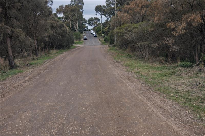
Williams Road includes an unsealed section that sits outside the current Armstrong Creek Urban Growth Area boundary. Historically, this section has functioned as a rural road and has not been upgraded as part of developer-led works. Sealing a road is considered an upgrade, not routine maintenance, and requires appropriate planning approvals, funding, and delivery mechanisms.

Yes. The City acknowledges ongoing community concerns about:

  • Children walking and riding to and from Mount Duneed Regional Primary School
  • Reduced visibility due to dust
  • Corrugation and uneven road surfaces
  • Increased traffic associated with surrounding development

The City continues to monitor the condition of Williams Road and manage it in line with the Road Management Plan, including inspections and grading where intervention levels are met.

The unsealed section of Williams Road experiences variable traffic volumes, which can lead to rapid re‑formation of corrugations after grading—particularly during dry conditions. Grading is a short‑term maintenance treatment used to address safety and drivability, but it does not provide a permanent solution for heavily trafficked roads.

Some sections of Williams Road between The Grange Estate and Feehans Road contain significant remnant native vegetation within the existing road reserve. Feehans Road faces similar constraints due to native vegetation, though to a lesser extent. 

While the City acknowledges community concerns regarding pedestrian and road safety, these environmental considerations, together with existing drainage infrastructure and underground services, currently limit opportunities to construct footpaths or undertake road widening works in these locations. 

As future development of the area progresses, Council will seek to ensure that developers provide the necessary road and footpath infrastructure upgrades in accordance with the City's requirements. At that stage, the works can be designed to extend across both the road reserve and adjoining private land, minimising the environmental constraints that currently limit our ability to deliver the infrastructure entirely within the existing road corridor.

In July 2024, Council adopted the Urban Geelong Long‑Term Settlement Boundary Review, which proposes extending the Armstrong Creek Growth Area boundary to align with Williams Road and Feehans Road. A planning scheme amendment is being prepared to enable this change.

Once finalised, this amendment will support the development of land at the intersection of Feehans and Williams Road . As the developer progress their development The City will look to impose conditions within the planning permit to ensure they provide the necessary infrastructure to support the area. Items such as the following will be pursued through the planning permit process when able:

  • Future sealing and upgrade of the remaining rural sections of Williams Road (north of Feehans Road)
  • Facilitate pedestrian and cycling connections to Mount Duneed Regional Primary School from the new subdivision land.

This is a longer‑term process that is expected to take several years.

Yes. In 2017, the City invested over $300,000 in works on Williams Road to improve parking and pedestrian access near Mount Duneed Regional Primary School. The City has also continued to liaise with the school community and relevant State departments regarding safe access, including preparing parking options for state funding consideration.

Upgrades within growth areas are typically delivered by developers as part of subdivision conditions. Williams Road sits partially outside the current growth area, meaning upgrades cannot be required through development permits at this stage. As a result, delivery timelines do not always align with nearby capital works.

Some recent truck movements, stockpiles, and on-site activity have been associated with utility or maintenance works rather than a full road upgrade. Where works are undertaken by other authorities or contractors, they are responsible for site safety, access management, and reinstatement of affected areas.

Speed limits on Williams Road are set in accordance with the Victorian Speed Zoning Guidelines, which consider factors such as road width, surface type, roadside environment, and adjacent land use. The differing speed limits reflect these varying conditions. The City has applied to the Department of Transport and Planning for a consistent 50 km/h speed limit along Williams Road, and signage will be updated if approval is granted.

Trucks over 5 tonnes are prohibited on Williams Road and on Feehans Road between Williams Road and Winery Road.

The National Heavy Vehicle Regulator (NHVR) is responsible for enforcing heavy vehicle restrictions. Suspected breaches can be reported via the NHVR Heavy Vehicle Confidential Reporting Line online or by calling 1800 931 785.

What is the City doing right now?

The City is:

  • Inspecting Williams Road regularly
  • Undertaking grading when Road Management Plan intervention levels are reached
  • Monitoring safety conditions
  • Progressing planning work to support future upgrades once statutory processes are complete

What can residents do?

Residents are encouraged to:

  • Continue reporting new or changed safety or surface condition issues through the City's customer request system
  • Stay informed about planning scheme updates affecting the area
  • Participate in future consultation as planning and funding pathways progress

The City appreciates the community’s ongoing engagement and understands the strength of concern regarding safety on Williams Road, particularly for children and families.

Page last updated: