A background Existing Conditions Report (Flora and Fauna) was prepared by Ecology and Heritage Partners in 2021 to inform the Avalon Corridor Strategy.
ACS - Environmental analysis
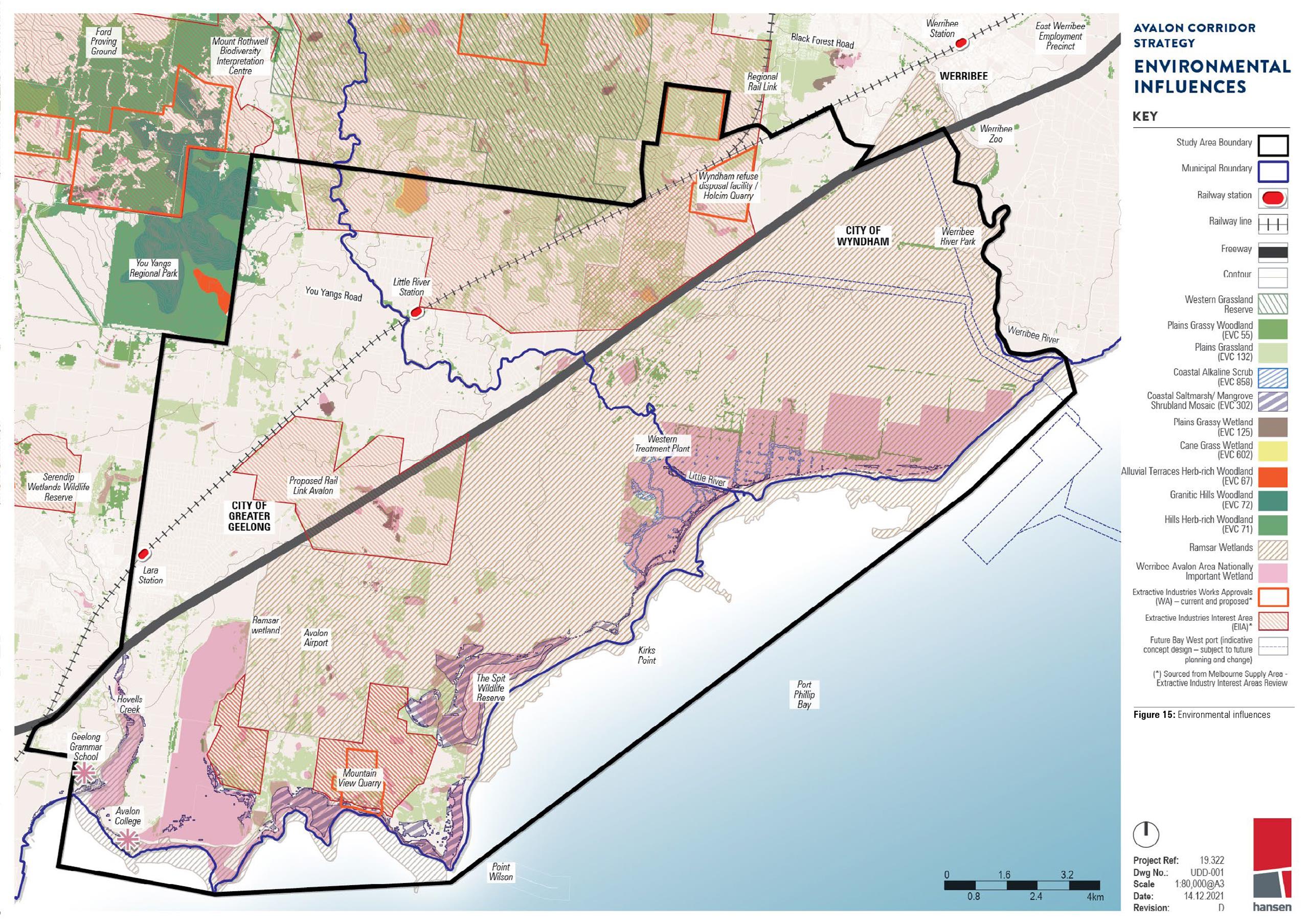
A summary of key findings and recommendations is provided in this section and Figure 15.
The legislative framework for environmental considerations in the Avalon Corridor includes obligations which exist under the Flora and Fauna Guarantee Act (1988). Public authorities and Ministers have duties under Section 4B to consider potential biodiversity impacts when exercising their functions.
Also of relevance is the Melbourne Strategic Assessment (MSA) program facilitated by the Victorian Government which seeks to protect biodiversity in Melbourne’s growth areas. Under the Commonwealth Environment Protection and Biodiversity Conservation Act (1999) (EPBC Act) four development actions that relate to the MSA program were approved. This means that developers don’t need any further approvals under the EPBC Act in affected growth areas as long as they follow relevant conditions set out under the MSA.
The Existing Conditions Report (Flora and Fauna) aimed to inform the Avalon Corridor Strategy by providing:
- An overview of the natural environment within and adjacent to the Avalon Corridor
- Maps and descriptions of the natural assets within and adjacent to the Avalon Corridor
- Identification of issues affecting natural assets that need to be considered
- Identification of opportunities affecting natural assets within the Avalon Corridor which could drive land use outcomes
- Identification of opportunities to integrate and grow natural assets with planning for open space drainage and broader land use planning.
The Existing Conditions Report (Flora and Fauna) identified the following key ecological values within the Avalon Corridor:
- Native vegetation including remnant patches and scattered trees
- 74 ‘Current Wetland’ sites mapped by DELWP
- Significant waterbodies including the WTP sewage treatment ponds former Cheetham Saltworks Werribee River Little River Lollypop Creek Cherry Tree Creek Hovells Creek Ryan’s Swamp Wetland Paul and Belfrages Swamp Edgars Road Swamp and Cherry Swamp
- The Port Phillip Bay and Corio Bay marine environment
- A diverse assemblage of plants and animals with 739 flora species and 469 fauna species previously recorded
- The known occurrence of 13 nationally significant and 79 state significant flora species recorded since 1980
- The known occurrence of 18 nationally significant 32 state significant and 17 regionally significant fauna species recorded since 1980
- The known and potential presence of ecological communities of national and state significance including the internationally significant Port Phillip (Western Shoreline) and Bellarine Peninsula Ramsar site and nationally important Werribee-Avalon Area wetland
- Conservation reserves including the Werribee Regional Park Port Phillip Bay Coastal Reserve Spit Wildlife Reserve Limeburners Bay Flora and Fauna Reserve Freshwater Swamp and Little River Wildlife Reserve and Western Grassland Reserve
- Sites of biological significance (BioSites) mapped by DELWP and CoGG
- Ecological values supported within the WTP
- Biodiversity corridors formed by established reserves waterbodies and tracts of native vegetation.
Key threats to ecological values identified in the Avalon Corridor include:
- The introduction and spread of diseases and invasive plant and animal species
- Direct impacts associated with vegetation clearing
- Inappropriate grazing and fire regimes
- Fragmentation of habitat and edge effects associated with expanding development
- Increased traffic (direct mortality)
- Changes to hydrology
- Chemical run-off sedimentation and erosion
- Impacts associated with climate change including direct loss of habitats and increases in ambient ultraviolet-B (UV-B) radiation.
- Increased community access.
Key considerations related to native grasslands and habitats under Commonwealth and Victorian Government regulations include:
- The difficulty in identification of grasslands (visually inconspicuous)
- Likely wide dispersal across the Avalon Corridor
- Likely high conservation significance
- Very limited offset opportunities for removal (offsets can be entirely unavailable).
Key recommendations for the Avalon Corridor Strategy and further work to be undertaken include:
- Further assess areas of native vegetation and populations of threatened species and communities.
- Retain areas of native vegetation (remnant patches and scattered trees) and habitat where possible.
- Improve and create biodiversity corridors within the Avalon Corridor potentially through revegetation activities that provide greater connectivity between established reserves waterbodies and tracts of native vegetation. Establish a formalised environmental corridor between the Western Grasslands Reserve and the coast through the WTP.
- Determine strategies to protect sensitive habitats from new industrial or commercial land uses and development as required.
- Ensure key ecological values are protected through the application of relevant overlays and other planning tools such as Precinct Structure Plans.
- Consider potential impacts of increased community access on areas of significant ecological value which have been relatively isolated and ensure appropriate protections are in place.
- Consider new and existing policy instruments that can be implemented to reduce the rate of habitat loss and its effect on biodiversity.
- Establish a new biolink along the Princes Freeway and create linear habitat corridors to link conservation reserves with the aim of supporting biodiversity.
- Determine whether developable land west of Avalon Airport is constrained by the presence of the Werribee-Avalon Area Nationally Important Wetland and habitat for state and federally listed species. It is recommended that any development proposed to be located west of Avalon Airport is subject to further investigation to confirm development potential.
- Consider relevant recommendations and actions for improvement and protection of waterway health from existing government strategies and policies.
The Existing Conditions Report was based on a high level assessment of ecological values within the Avalon Corridor drawing predominately on the findings of a detailed desktop review. The report concludes that “any future development proposals within the study area must be informed and supported by detailed ecological studies including vegetation surveys and targeted surveys for significant species of flora and fauna.”
The Western Grassland Reserve was established by the Victorian Government covering 15 000 hectares outside the UGB southeast of Melton and west of Werribee. The area contains the largest and highest quality example of Natural Temperate Grassland remaining in Victoria and is a key biodiversity asset for the state. The reserve also protects a range of habitat types including ephemeral wetlands waterways Red Gum swamps rocky knolls and open grassy woodlands. The reserve will connect the You Yangs Regional Park to the Werribee River across the Victorian Volcanic Plains. Land in the Western Grassland Reserve is subject to a PAO and ESO under relevant planning schemes.
The Western Grassland Reserve is central to the Melbourne Strategic Assessment (MSA) program - a long term initiative that works alongside urban development in Melbourne’s growth areas. 18 percent of land within the Western Grassland Reserve has already been purchased resulting in permanent protection for more than 2 630 hectares of threatened grasslands and wetlands. Negotiations with landowners to acquire more land are ongoing and are funded by revenue raised through the MSA Levy.
WCC is a delivery partner for the Western Grassland Reserve and has supported landowners to control weeds on more than 3 220 hectares of private land. Other activities include controlled burning spraying artichoke thistle with drones planting native grasses managing serrated tussock and cane needle grass and surveying 1 264 hectares of vegetation.
Select areas of the Western Grassland Reserve have been identified as containing strategic extractive resources (hard rock and gravel) needed for the construction industry. These areas were identified by the Victorian Government’s SERA pilot project with new planning controls introduced over affected land. Other areas of the Western Grassland Reserve were identified by Infrastructure Victoria as having potential value in accommodating a rail stabling yard associated with the future Bay West Port proposal. This includes land immediately to the west of the alignment of the OMR Transport Corridor.
These alternate uses pose a potential land use conflict with the designation of the Western Grassland Reserve for biodiversity conservation. Such conflicts would need to be further considered and addressed through relevant planning processes at the state government level. It is not the intention of the Avalon Corridor Strategy to resolve all potential land use conflicts identified.
The Port Phillip (Western Shoreline) and Bellarine Peninsula Ramsar site covers approximately 15 182 hectares (51 percent) of the study area. The entire Ramsar wetland covers an area of approximately 22 897 hectares.
The Ramsar site is characterised by:
- A range of marine and inland wetlands characteristic of the South East Coastal Plain bioregion as well as artificial wetlands.
- Significant habitat that provides one of the most important sites in Victoria for migratory shorebirds and supports more than 20 000 waterbirds (including large numbers of migratory waders black swans ducks ibis and cormorants).
Any potential future development in close proximity to the Ramsar site would need to consider possible direct and indirect impacts on the wetlands and may need to be referred to the Commonwealth Department of Climate Change Energy the Environment and Water (DCCEEW). Impacts could include loss of habitat for migratory wetland birds or reductions in water quality.
Development would need to have regard to the policy for managing Ramsar sites in Victoria as set out in the Victorian Waterway Management Strategy (DEPI 2013) as well as the Port Phillip (Western Shoreline) and Bellarine Peninsula Ramsar Site Management Plan (DELWP 2018).
In addition to the internationally significant Ramsar site the Avalon Corridor contains approximately 3 220 hectares of the Werribee-Avalon Area Nationally Important Wetlands which is listed on the Australian Directory of Important Wetlands (DoEE 2016) and are covered under the Ramsar Convention on Wetlands (1971). The extent of the Werribee-Avalon Area Nationally Important Wetlands overlaps with the Ramsar site and includes additional areas to the north including the former Cheetham Saltworks site.
The Avalon Corridor encompasses approximately 6 900 hectares of the Port Phillip Bay and Corio Bay marine environment. While there are no marine national parks or sanctuaries present the boundaries of the Spit Wildlife Reserve and Port Phillip Bay Coastal Reserve encroach into the intertidal areas of Port Phillip Bay and Corio Bay.
Mapping was undertaken by Natural Resource Systems for the Land Conservation Council as part of a Marine and Coastal Special Investigation. This investigation encompassed the marine area of the Bidentified that the Bates Point Aquaculture Fisheries Reserve - a 20 hectare area located approximately 900 metres south of Bates Point. The investigation found that the marine environment supports a range of habitat types including intertidal sandy beaches seagrass beds and subtidal rocky reefs. Seagrass and microalgae mapping datasets held by the Victorian Department of Jobs Precincts and Regions (DJPR) also indicate that seagrass beds and large areas of macroalgae are present.
Climate change is increasing the risk and severity of coastal hazards as a result of sea level rise and more frequent and severe extreme weather events. This will impact on the future use and development of land along the coast and inland locations along waterways. Understanding the dynamic processes of the coastal environment within the Avalon Corridor is important for ensuring any future development responds appropriately to these increased risks.
In the context of Port Phillip Bay key risks to the coastline resulting from sea level rise include:
- Coastal inundation - this includes both permanent inundation which will see high tide levels permanently increase as a result of sea level rise and periodic inundation caused by the combined effects of high tide and storm surge events.
- Coastal erosion - the shoreline will be progressively eroded and moved inland as a result of sea level rise and storm surges. The level of vulnerability is greatly affected by the geology of the shoreline.
- Groundwater change and salinity - as sea levels rise the underground water table will also increase in height and salinity which can affect groundwater and soils. This can potentially impact on buildings infrastructure vegetation and crops. There is currently limited data available to understand the likely risks associated with this hazard in the Avalon Corridor and Port Phillip Bay more broadly.
Current state planning policy seeks to plan for sea level rise of no less than 0.8 metres by 2100. This benchmark is subject to evolving science and international standards that could result in an increase to 1.1 metres. The current benchmark is based on the Intergovernmental Panel on Climate Change’s Fifth Assessment Report (2014) which projects sea level rise between 0.52 to 0.98 metres by 2100.
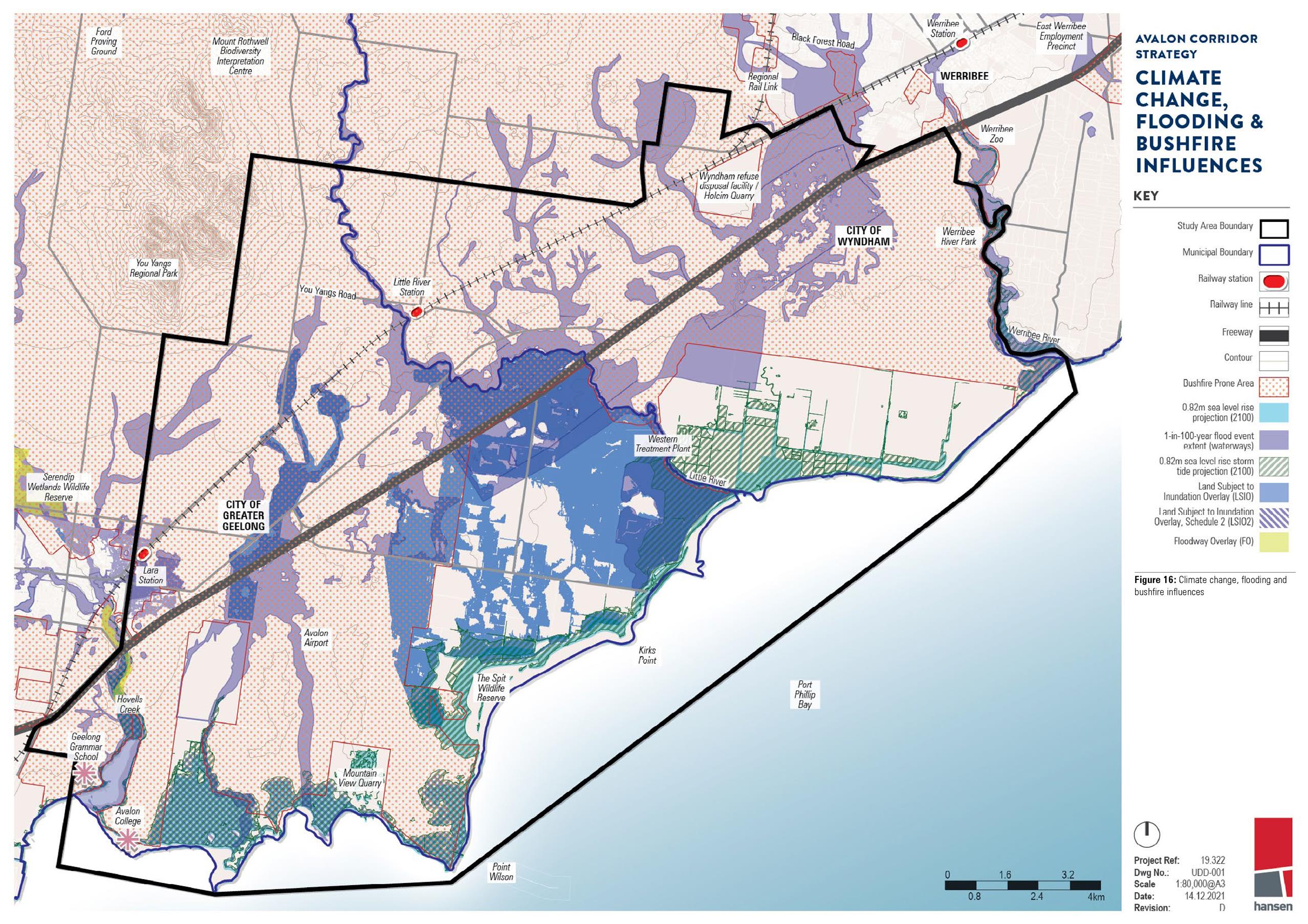
The Victorian Coastal Inundation Dataset was released by DELWP in 2012 and provides a high level assessment of the risks associated with sea level rise and storm surge along the Victorian coast. The regional scale data provides an understanding of both permanent and periodic inundation under various scenarios out to 2100. The data includes a layer that is based on a 0.8 metre increase to the high water mark for permanent inundation with a 1% Annual Exceedance Probability (AEP) storm tide flood event added for periodic inundation.
Amendment VC171 (gazetted September 2021) makes changes to the VPPs to implement the Marine and Coastal Policy (DELWP 2020) support coastal hazard planning and sea level rise adaptation and update policy references. Functionally the changes strengthen the planning scheme provisions to plan for and mitigate coastal hazard risk to reduce the exposure of settlements to coastal hazard risks.
CoGG has undertaken further work as part of the Our Coast project which involved the preparation of the detailed Bellarine Peninsula - Corio Bay Local Coastal Hazard Assessment (2015). This work resulted in updates to the Land Subject to Inundation Overlay (LSIO) in the Greater Geelong Planning Scheme including a new Schedule (LSIO2) that was introduced as part of Amendment C394ggee (September 2020). LSIO2 applies to land affected by the combined impacts of a 1% AEP flood event and a 0.8 metre sea level rise.
DELWP’s Coastal Erosion Vulnerability mapping provides an indication of sections of the Victorian coast that are most vulnerable to erosion. While the data is high level areas of high and very high risk have been mapped along the Avalon Corridor coastline (see Figure 16).
A large portion of land within the Avalon Corridor affected by coastal inundation under a 0.8 metre sea level rise scenario is classified as public land with a direct interface to the coast or tributaries. Responding to the impacts of sea level rise in these locations will generally be the responsibility of the various public land managers and authorities.
The most significantly impacted location is the WTP. Engineered solutions and protection measures will play a significant role in locations that contain state significant infrastructure to ensure ongoing viability and reliability of assets.
A significant portion of the salt production and aquaculture activities surrounding the Avalon Coastal Reserve is projected to be periodically and permanently inundated. Areas within this location are also subject to high or very high vulnerability to coastal erosion.
Planning responses that seek to manage the use and development of land to mitigate risks of climate change sea level rise and flooding will have a role to play within the Avalon Corridor. As recognised by the application of the LSIO in Greater Geelong built form solutions related to the siting of buildings and floor level heights are necessary in vulnerable locations. Such solutions should also be considered during detailed design for the future Bay West Port.
There is a need to ensure land use and development consider flood risk to the satisfaction of Melbourne Water or the relevant Floodplain Management Authority. Where severe risks are identified the long term development viability of the land will need to be considered. Options could include restricting sensitive uses limiting the intensification of existing activity or identifying planned retreat options.
Of further note CoGG exhibited Amendment C339ggee in 2021 which seeks to address riverine flooding risk through the targeted application of the Flood Overlay and LSIO to land within and beyond the Avalon Corridor.
Reports underpinning Amendment C339ggee include:
- Bellarine Peninsula - Corio Bay Local Coastal Hazard Assessment (2015)
- Lower Barwon and Lower Moorabool Flood Investigation (2018)
- Lara Flood Study (2020)
Although no areas of the Avalon Corridor are covered by the Bushfire Management Overlay (BMO) large sections are mapped as Designated Bushfire Prone Areas as illustrated in Figure 16.
Such areas are identified by the Bushfire Prone Area (BPA) Map which was introduced in response to the recommendations made by the 2009 Victorian Bushfires Royal Commission. The Minister for Planning makes a formal determination to designate BPAs under section 192A of the Building Act (1993) based on Bushfire Hazard Level - an indicator of how extreme a bushfire can be based on landscape conditions.
The BPA Map identifies bushfire hazards for most of Victoria including grassland areas. Minimum construction standards apply to new residential buildings schools child care centres hospitals aged care facilities and associated buildings in designated BPAs. For example a minimum Bushfire Attack Level (BAL) of 12.5 is applied to certain buildings such as dwellings.
Noting that the BMO does not apply within the Avalon Corridor potential impacts of bushfire need to be considered on a case-by-case basis as part of specific applications for building and planning permits.
Activities within the Avalon Corridor potentially involve the removal and transportation of plant material through the use of various machines vehicles and equipment. This creates risks of spreading plant diseases and pest plants (weeds).
The Avalon Corridor is noted to contain a range of environmental and noxious weeds such as Chilean needle grass and serrated tussock which threaten native vegetation and agricultural activities.
Preventing further spread of weeds and invasive flora species should be a priority for land managers.
Wetlands waterways and the coastal interface are characteristic landscape and ecological features of the Avalon Corridor. Landscape scale and site specific hydrological knowledge is required to ensure these environmental assets can function appropriately alongside current and future land uses.
Overland flows and stormwater management must be carefully considered across the entire Avalon Corridor area in particular areas flagged for development and land use change. Freshwater inputs into saline environments can be detrimental to the point of impacting on Matters of National Environmental Significance (MNES). Salinity is therefore a relevant consideration to the Avalon Corridor both in terms of its relation to ecological systems and the constraints it may place on certain types of development.
Management arrangements will need to be considered which support the protection and function of the Werribee-Avalon Area Nationally Important Wetlands (reference: VIC121) particularly the former Cheetham Saltworks site. The functioning of these ponds is reliant on hydrological regimes that extend beyond the area of Crown land managed by Parks Victoria.
It is further important to ensure development considers and mitigates risks associated with the disturbance of coastal acid sulphate soils which may be present within the Avalon Corridor.
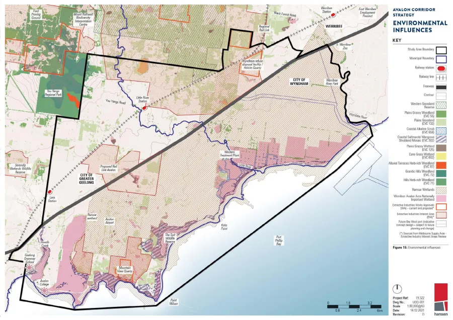
ACS - Figure 15 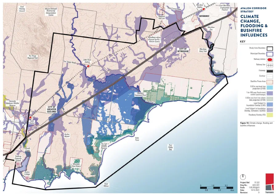
ACS - Figure 16
Click on an image to view details and enlarge
Page last updated: