There are two parts to section 16 of this strategy.
ACS - Implementation
1. Framework plan implementation
The Avalon Corridor Strategy provides a long term strategic vision of the Avalon Corridor to ensure planning decisions on individual sites are made in context of the broader vision for the region. The Avalon Corridor Strategy has been tasked with preparing strategic guidance for a large tract of land, which extends from the eastern edge of Geelong to the western edge of Werribee.
The key output of the Avalon Corridor Strategy is the Framework Plan, which outlines the broader spatial pattern of land use for the Avalon Corridor and identifies relevant objectives and strategies for sub-precincts. The Framework Plan is high level in focus and therefore does not go into details that will be determined through subsequent planning processes, such as the development of Structure Plans for the GAEP, Werribee Junction and Mambourin East.
The Werribee urban interface area as illustrated on the Framework Plan will be the subject of further detailed investigations and concept planning associated with the preparation of the Werribee Junction and Mambourin East PSPs. These PSPs are to be led and developed by the VPA in collaboration with WCC.
The Mambourin East PSP and majority of the Werribee Junction PSP are identified as ‘regionally significant industrial precincts’ for potential employment uses focused on industry and logistics, per the West Growth Corridor Plan, Melbourne Industrial and Commercial Land Use Plan (MICLUP) and Draft Western Metro Land Use Framework Plan. Land use relating to industry and logistics in these PSPs will likely benefit from proximity to Avalon Airport, the future Bay West Port and the OMR Transport Corridor.
While the Framework Plan sets out the broader directions for land use and development, it will be necessary for further detailed work to be completed to assess a range of specific land use/ development issues and options at and surrounding Avalon Airport.
The Framework Plan identifies land which has potential for commercial/ industrial airport related development given locational attributes and proximity to Avalon Airport. However, it is not a matter of simply rezoning and redeveloping individual sites around the airport on a piecemeal basis, as this could undermine the intent of why the Avalon Corridor Strategy is being prepared i.e., the significant opportunities provided by an integrated airport and related commercial business precinct focused on Avalon Airport.
Therefore, it will be necessary to prepare a Structure Plan for the land identified in the Framework Plan as ‘potential commercial / industrial / airport related business’ which will function to strategically consider the optimal arrangement and integration of future land use and development of land surrounding the Avalon Airport, and would be broadly guided by the Avalon Corridor Strategy and Framework Plan. During the planning and development of the Structure Plan there is a need to consider practices and principles relating to Water Sensitive Urban Design (WSUD) and Biodiversity Sensitive Urban Design (BSUD), particularly for land west of Avalon Airport.
It will be the role of the Structure Plan to investigate and develop an appropriate response to key matters prior to development proceeding. Although the Avalon Corridor Strategy sets highlevel land use and policy direction, more detailed matters will need to be addressed through relevant structure planning processes.
Functionally speaking, the Structure Plan would be informed and guided by the broader findings, conclusions and recommendations of the Avalon Corridor Strategy. The preparation of a Structure Plan would enable the consideration of all specific issues at a detailed and comprehensive level, to achieve the best outcome for the entire airport precinct. This approach avoids addressing issues on a site by site basis, which could lead to a fragmented assessment, consequently undermining the opportunity to maximise the potential to develop this area as a fully integrated airport and related precinct.
Given a Structure Plan functions to take a precinct wide approach, it allows precinct wide issues to be considered and addressed. For example, through the preparation of a precinct wide transport management strategy and precinct wide drainage catchment strategy, where an optimal response to such matters can be embedded into the Structure Plan. This process then also allows the preparation and implementation of a Development Contributions Plan (DCP) to fund required items, such as drainage as one particular example.
It is also highlighted that the Framework Plan contains numerous elements which fall outside of the immediate control of Greater Geelong and Wyndham Councils to influence or implement, with these relating to matters of state significance such as:
- Avalon Airport being granted approval for further international flights
- Construction of improved public transport connections to Avalon Airport
- Construction of the OMR Transport Corridor
- Construction of the Bay West Port as the preferred port option and its potential construction.
- Incorporate necessary policy references within the Planning Policy Framework (PPF), including State, Regional, Local and MSS of both the Greater Geelong and Wyndham Planning Schemes.
- Incorporate necessary policy references within the G21 Regional Growth Plan.
- Implement overlay controls to address airport noise contours and building height restriction associated with the functional operation of Avalon Airport.
- Implement required zones and overlays in the short term to protect long term development opportunities associated with the Bay West Port.
- Consider amending the existing Farming Zone of the Geelong Motor Sports Complex to recreational open space or other suitable zone, which could be facilitated via a future rezoning associated with the implementation of the Greater Avalon Employment Precinct Structure Plan.
The above implementation of the Avalon Corridor Strategy into the Greater Geelong and Wyndham Planning Scheme should be undertaken in the short term (0-2 years).
2. Further work to be undertaken
The Framework Plan functions as high level strategic planning strategy to guide future land use and development. However, the Framework Plan is not resolved to a level to contemplate and spatially map out all potential future land use and development, nor address every potential issue to a specific and detailed level.
Accordingly, the next level of detailed strategic analysis will be captured by other formal steps involved in the consideration of the future land use and development, including:
- Planning Scheme Amendment process to implement aspects of this strategy;
- Preparation of detailed Structure Plans for key future development areas; and
- Required statutory approvals for site specific proposals.
In the final drafting stages of this Strategy, the Victoria Planning Authority (VPA) were appointed by the Minister for Planning to become the planning authority to prepare a Structure Plan for the proposed employment precinct adjacent to Avalon Airport, known as the Greater Avalon Employment Precinct (GAEP). Initial background site investigations for the Structure Plan has already commenced by the VPA.
Following below is further strategic work which should be undertaken by CoGG and WCC (as applicable), following the formal adoption of this strategy. This list is not exhaustive, and other items of work are likely to be identified in due course. Future work to be actioned includes the following which has been set out in terms of short, medium and longer term priority:
- CoGG to work with the VPA to commence the preparation of a Structure Plan for the GAEP (refer to Section 16.1 for further discussion and detail on the role and function of the Structure Plan), including:
- Undertake detailed environmental assessments of land immediately to the west of Avalon Airport to consider potential impacts of future development on identified Werribee-Avalon Area Nationally Important Wetlands (NIW).
- CoGG and/or the VPA and DoT to assess movement and access in developing the Structure Plan, including:
- The long-term role of Point Wilson Road for passenger and freight access to Avalon Airport and access to Little River.
- Upgrades of Beach Road and Avalon Road interchange to accommodate future passenger and freight growth.
- WCC and the VPA to continue the preparation of the Werribee Junction and Mambourin East PSPs in a manner that is consistent with the high-level objectives and land use guidance of the Avalon Corridor Strategy.
- VPA to undertake further environmental assessments as part of the investigation and confirmation of the Greater Avalon Employment Precinct Structure Plan including mitigation of stormwater runoff on wetlands, and the current values of the nationally important wetlands (Former Cheetham Saltworks) to the west and south of Avalon Airport.
- CoGG, WCC, DELWP and WTOAC to undertake further analysis and investigation regarding the potential expansion of the SLO to address cultural values, noting that:
- The Cultural Values Assessment completed for the Avalon Corridor Strategy included a recommendation from the WTOAC to look at extending the SLOs for the You Yangs (Wurdi Youang) and Anakie Ranges.
- This request is influenced by current work of DELWP, which is considering the purpose and use of SLOs on a number of fronts, including whether SLOs are an appropriate tool for protecting cultural heritage.
- CoGG and WCC to advocate to CCMA, Melbourne Water and Barwon Water to improve catchment health through relevant IWM Forums, including returning environmental flows and creating wildlife corridor through to WTP.
- CoGG and WCC to confirm alternate water supply opportunities for the Avalon Corridor region, such as through development of Integrated Water Management (IWM) plans with relevant stakeholders (e.g. Melbourne Water, Barwon Water and Greater Western Water), in consultation with relevant IWM Forums.
- CoGG and WCC to investigate opportunities to create a strategic biodiversity link between the You Yangs, the adjacent native grassland remnants, and the Western Grasslands Reserve.
- CoGG to review outstanding post-contact heritage recommendations for Heritage overlays identified in the Outer Areas Heritage Study and investigate the HO potential of early dry stone walls and other features in the area, as part of a five year program looking at the Outer Areas.
- WCC to implement the recommendations of the Stage 1 Heritage Review Gap Study2019 as endorsed by Council in June 2021; this work is proposed to be carried out in a staged manner in the next one to five years.
- CoGG, in discussion with Heritage Victoria and community groups, to explore the potential inclusion of the Wurdi Youang/You Yangs in the Victorian Heritage Register or a Heritage Overlay.
- DoT, COGG and WCC to undertake further investigations to understand the need for transport network upgrades, based on current and future demand.
- CoGG and WCC to work together to prepare a township plan for Little River and to establish a township settlement boundary to restrict further urban/residential expansion.
- CoGG and WCC to further investigate investment and infrastructure needs for facilitating sustainable ecotourism activities such as fishing, birdwatching, water sports, bay trail rides in the corridor.
- CoGG and WCC to investigate and consider opportunities with DELWP and Parks Victoria to expand coastal park and Ramsar wetland areas on publicly owned land.
- CoGG and WCC to review the Avalon Corridor Strategy and associated Framework Plan, if justified by significant changes to overarching state policy and land use directions for the Avalon Corridor.
Beyond matters that CoGG and WCC can action, further work has been identified which should be undertaken by other organisations:
- Relevant state government departments to urgently undertake further design to define the port site location and supporting connections, and investigate the implementation of appropriate planning scheme mechanisms to protect future potential alignment/s to facilitate the preferred location of the Bay West Port.
- Relevant state government departments to undertake further work to address connectivity and expansion of significant biodiversity and native vegetation areas, including Ramsar sites, coastal reserves, waterways/wetlands, conservation reserves, patches of native vegetation and biosites etc.
- Relevant state government departments to undertake further work to assess potential environmental and cultural heritage impacts of major infrastructure projects, such as the Bay West Port.
- Relevant state government departments to undertake further work to assess potential buffer requirements around high value biodiversity areas for prevention of noise/light/pollution impacts, particularly with regard to migratory birds around Ramsar wetlands and WTP.
- Relevant state government departments to advance acquisition and protection of the Western Grasslands Reserve and to resolve any potential existing or future land use conflicts within the reserve.
- Relevant state government departments to undertake a further work to analyse timing, sequencing and delivery of major various projects within the Avalon Corridor (i.e. OMR Transport Corridor, Bay West Port etc.).
- Relevant state government departments to undertake further work to preserve the functional importance of the Princes Freeway and rail link between Werribee and Geelong including considerations of:
- Safeguarding against climate change
- sea level rise, intense rainfall and increased flooding.
- Resilience for longer-term freight security
- including backup routes in case of closure and functional limits on bridges and culverts.
- Avalon Airport to finalise and incorporate the proposed ANEF into a revised Master Plan, in consultation with relevant local, state and federal government departments/ agencies. Interim planning work for and around the airport (including the proposed PSP for the Avalon employment precinct) to protect the option to develop a second parallel and third cross runway, as signalled under the current 2015 Master Plan, unless superseded by an updated Master Plan.
- CoGG and WCC to liaise with relevant entities to identify and protect remaining volcanic ecosystems.
- DELWP to further investigate the extent and condition of native grasslands predicted to be present in the study area.

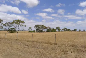
ACS - Open rural landscapes north of the Princes Freeway 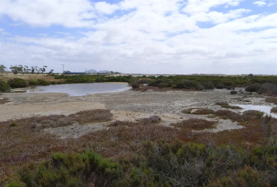
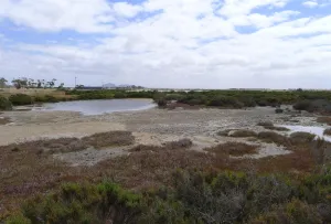
ACS - Former Cheetham Saltworks site with longer range open views to Wurdi Youang
Click on an image to view details and enlarge
Page last updated: