The Avalon Corridor is an area of approximately 30,000 hectares of land between Geelong and Melbourne.
Acknowledgement of Country Appendix One Avalon Airport Analysis Cultural values and heritage analysis Economic Analysis Emerging trends and influences Environmental analysis Executive summary and vision statement Figures, diagrams and abbreviations Framework Plan Implementation Introduction Landscape character analysis Land use analysis Metropolitan and municipal context Opportunities, constraints and issues Strategic land use studies and planning policy Toward a conceptual framework plan Transport analysis Utilities servicing analysis
It contains a number of state and regionally significant assets such as Avalon Airport and the Melbourne Water Western Treatment Plant (WTP).
It encompasses the township of Little River and parts of Lara, and accommodates a wealth of biodiversity values and landscapes of environmental and cultural importance.
The Avalon Corridor requires clear strategic guidance regarding potential land use and development change, and direction on how to foster opportunities associated with its strategic location and the presence of significant assets and infrastructure.
Within this context, the Avalon Corridor Strategy (the Strategy) has been prepared to provide a long-term strategic vision for the Avalon Corridor to 2050 in order to guide planning decisions for individual sites and the surrounding region.
The Avalon Corridor Strategy has been jointly commissioned by the City of Greater Geelong (CoGG) and Wyndham City Council (WCC), in collaboration with the Victorian Department of Environment, Land, Water and Planning (DELWP).
The development of the Avalon Corridor Strategy has involved:
- Desktop review of existing strategic work which either broadly or specifically considers the future land use and development potential of the Avalon Corridor.
- Examination of opportunities and constraints within the Avalon Corridor with a view to define areas capable of being developed and areas to be retained as part of a green break to separate urban Melbourne and Geelong and to protect the area’s significant views, grasslands and wetland habitat areas and cultural heritage.
- Engagement with major stakeholders – including local and state government, Melbourne Water, Avalon Airport, Wadawurrung Traditional Owners and other major landowners – to inform the preparation of the Strategy and to guide future development within the corridor.
- Development of a Framework Plan suitable for inclusion in the Wyndham and Greater Geelong Planning Schemes.
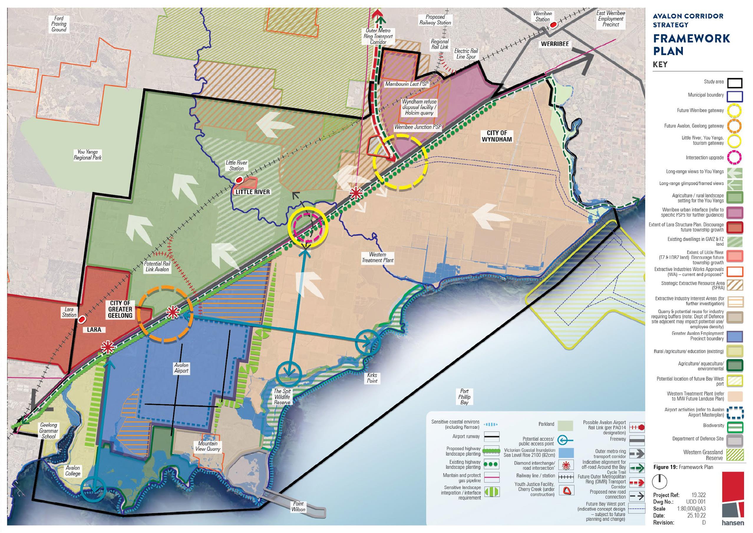
The key output of the Avalon Corridor Strategy is the Framework Plan (Figure 19), which outlines strategic guidance on the broader pattern of land use within the corridor and provides direction for future land use and development. The Framework Plan outlines various objectives and strategies at broad and precinct/sub-precinct level that relate to the strategic context and spatial representation of land uses across the corridor. These objectives and strategies will need to be considered when planning for future land use and development proposals.
The key guiding principles which underpin the Framework Plan include:
- Maintain and reinforce a green break between Geelong (regional Victoria) and Werribee (metropolitan Melbourne).
- Protect green wedge and rural landscapes, as well as cultural and environmental features of identified value.
- Protect ongoing and future operations of the Western Treatment Plant.
- Protect ongoing and future expanded functional operations of Avalon Airport as per Avalon Airport, Master Plan.
- Focus appropriate commercial and industrial development within and surrounding Avalon Airport, as per the Framework Plan.
- Create economic development and employment opportunities in the northern part of Geelong.
- Highlight the ongoing importance of the economic and transport connections between Werribee and Geelong.
- Protect and enhance traffic movement on major roads (current and proposed) and rail corridors.
- Avoid residential development within the Avalon Corridor.
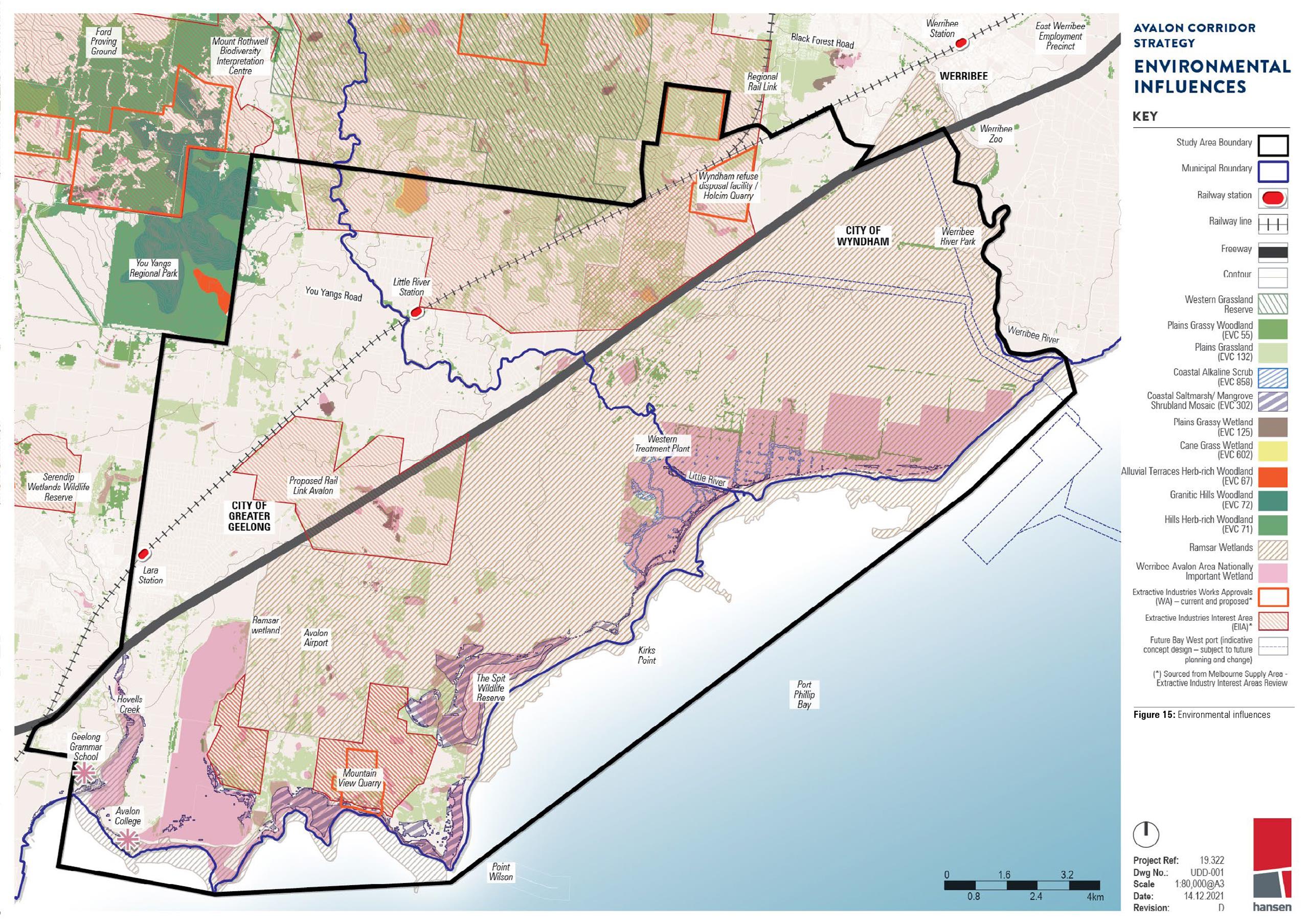
- Protect areas of acknowledged environmental value including coastline and Ramsar wetlands and grasslands (Figure 15).
- Protect Wadawurrung cultural values and areas of known cultural heritage significance, as well as post-contact heritage sites (in addition to undertaking further investigations as part of specific land use change and development proposals).
Although the Framework Plan sets out the broader directions for land use and development within the Avalon Corridor, it cannot anticipate all potential land use and development proposals of state or regional significance. Therefore, it needs to be flexible enough to be able to consider alternate outcomes which have not previously been identified. It will also be necessary for further detailed work to be completed, as outlined in Section 16.
Future work to be undertaken includes (but is not limited to) the following:
- Progressing relevant planning scheme amendments to implement the Avalon Corridor Strategy.
- Reviewing the extent of relevant Significant Landscape Overlays (SLOs).
- Developing Precinct Structure Plans (PSPs) for Werribee Junction and Mambourin East, as well as a Structure Plan for a Structure Plan for the proposed Greater Avalon Employment Precinct.
- Undertaking further environmental and cultural heritage assessments prior to future land use or development changes.
- Undertaking further assessments of movement and access within the corridor, particularly around proposed development areas.
- Reserving land required for major infrastructure projects, such as the Bay West Port.
- Establishing a formal township settlement boundary around Little River.
- Working with Avalon Airport to finalise the proposed Australian Noise Exposure Forecast (ANEF) and revise the Avalon Airport Master Plan, as required.
Vision Statement
The Avalon Corridor will continue to provide a green break between Geelong (regional Victoria) and Werribee (metropolitan Melbourne), while protecting areas of recognised environmental, landscape, heritage and cultural value.
It will limit residential growth while supporting the expanded operations of Avalon Airport as Victoria’s second international airport and fostering new land use, development and employment opportunities on airport land and immediate surrounds (as appropriate).
It will protect operations of the Western Treatment Plant to ensure it can continue to provide low-cost sewage treatment, recycled water for irrigation and support broader biodiversity values in the region.
In this section
Acknowledgement of Country Appendix One Avalon Airport Analysis Cultural values and heritage analysis Economic Analysis Emerging trends and influences Environmental analysis Executive summary and vision statement Figures, diagrams and abbreviations Framework Plan Implementation Introduction Landscape character analysis Land use analysis Metropolitan and municipal context Opportunities, constraints and issues Strategic land use studies and planning policy Toward a conceptual framework plan Transport analysis Utilities servicing analysisPage last updated:
We are glad that you find this page helpful!
Submitting feedback... Please wait.
An error occured! Please try again.
Feedback submitted successfully!
Thank you for your feedback. We value your input and will use it to improve our services.