There are four parts to this section of the strategy.
ACS - Strategic land use studies and planning policy
A wealth of existing background documentation is available which provides relevant strategic context for the Avalon Corridor.
This work is critical for understanding the evolving scope of strategic influences within the Avalon Corridor which have influenced the findings and recommendations relating to the Avalon Corridor Strategy.
A desktop analysis was undertaken of key policy and strategy documents across a range of professional expertise. An overview of key documents is provided in the following sections along with a summary of key findings and directions.
A substantial number of background strategic land use related studies have been prepared which have either direct or indirect relevance to the Avalon Corridor Strategy. These include:
- Plan Melbourne 2017-2050 (DELWP, 2017)
- Rural Land Use Strategy (CoGG, 2007)
- Outer Metropolitan Ring/E6 Transport Corridor Planning Assessment Report (VicRoads, 2009)
- Delivering Melbourne’s Newest Sustainable communities: Program Report (Victorian Government, 2009)
- Werribee-Geelong: Planning Investigation of Strategic Intent Developable Land Analysis (Department of Transport Planning and Local Infrastructure, 2014)
- G21 Regional Growth Plan and Implementation Plan Background Report (G21, 2013)
- South West Victoria Landscape Assessment Study - Regional Overview Report: 2013
- Avalon Airport Rail Link: Rail Corridor Establishment: September 2014, Department of Transport Planning and Local Infrastructure
- Native Vegetation Precinct Plan: Geelong Ring Road Employment Precinct (Amendment C423) (Ecology Partners Pty Ltd, 2013)
- Victorian Coastal Strategy (Victorian Government, 2014)
- West Growth Corridor Plan (Growth Area Authority, 2012)
- Avalon Airport Master Plan (Avalon Airport, 2015)
- Inundation Report: Bellarine Peninsula – Corio Bay Local Coastal Hazard Assessment (Cardno, 2015)
- Extractive Resources in Victoria: Demand and Supply Study 2015-2050 (PWC, 2016)
- Werribee South Green Wedge Policy and Management Plan (Wyndham City Council, 2016)
- Victoria’s 30-Year Infrastructure Strategy (Infrastructure Victoria 2016)
- Preparing Advice on Victoria’s Future Port Capacity: Discussion Paper (Infrastructure Victoria, 2016)
- Second Container Port Advice: Evidence Base (Infrastructure Victoria, 2017)
- Port Phillip Environmental Management Plan 2017-2027 (DELWP, 2017)
- Avalon Airport Ground Transport Plan (Avalon Airport, 2017)
- Protecting Victoria’s Environment – Biodiversity 2037 (DELWP, 2017)
- City Forest and Habitat Strategy 2017-2040 (WCC, 2017)
- Healthy Waterways Strategy 2018-28 (Melbourne Water, 2018)
- Port Phillip Bay (Western Shoreline) and Bellarine Peninsula Ramsar Site Management Plan (DELWP, 2018)
- Helping Victoria Grow – Extractive Resources Strategy (DEDJTR, 2018)
- Western Rail Plan (Victorian Government, 2018)
- Western Plains South Green Wedge Management Plan: Background Report (WCC, 2018)
- Melbourne Sewage Strategy (Melbourne Water, 2018)
- Industrial Land Supply Report (CoGG, 2018)
- Victorian Freight Plan: Delivering the Goods (DJPR, 2018)
- Avalon Signage Audit (SMEC, 2019)
- Greater Geelong Settlement Strategy (CoGG, 2020)
- Strategic Extractive Resource Areas Pilot Project (DELWP, 2020)
- Planning for Melbourne’s Green Wedges and Agricultural Land: Consultation Paper (DELWP, 2020)
- Avalon Airport ANEC Study: Noise modelling report (GHD, 2020)
- Victoria’s 30-Year Infrastructure Strategy (Infrastructure Victoria, 2020)
- Lara Flood Study (Amendment C339) (CoGG, 2020)
- Lower Barwon and Lower Moorabool Flood Investigation (DELWP, 2019)
- Bellarine Peninsula - Corio Bay Local Coastal Hazard Assessment (DELWP, 2015)
- Marine and Coastal Policy (DELWP, 2020)
- Wyndham Coastal and Marine Management Plan 2020-2025 (WCC, 2020)
- Independent review of the Victoria Ports System (Victorian Government, 2021)
- Draft Western Metro Land Use Framework Plan, 2021 (DELWP, 2021)
The context and influence of these documents have been analysed along with a further analysis of a range of further municipal level strategies which have relevance with the context of the WCC and CoGG. The following text is a high level abridged summary of the key matters of influence and relevance to the Avalon Corridor Strategy.
The Avalon Corridor has been acknowledged as a strategic location of cultural values, economic assets, natural resources and existing infrastructure including:
- Avalon Airport
- Point Wilson Munitions Facility
- Western Treatment Plant (WTP)
- Existing major road and rail infrastructure
- Areas containing strategic extractive resources (hard rock and gravel) needed for the construction industry
- Ramsar-listed wetlands
- Landscapes of recognised importance
- Cultural heritage and values
- Regional waterways
- Commonwealth and State-listed flora, fauna and communities
- Green wedge land.
- The State significance and strategic importance of Avalon Airport is strongly highlighted through various documents, noting it provides opportunities for domestic travel and future growth in international capacity, freight services, and aeronautical industry.
- Avalon Airport is acknowledged as an important major employment node in Geelong’s north, which also promotes economic opportunities on adjacent land. This precinct benefits from proximity and links to the Geelong Ring Road Employment Precinct, Geelong Port and freight and passenger rail networks. It therefore has major potential relating to export of regional products.
- A future rail link to Avalon Airport connecting Melbourne and Geelong passengers has been contemplated by a number of studies, with a preferred alignment protected through the application of a Public Acquisition Overlay (PAO14).
- The federally endorsed Avalon Airport Master Plan (2015) outlines future development plans, including details for ground transport and surface access. Excluding current runways and associated taxiways, the Master Plan notes that total developable land at Avalon Airport is approximately 1,600 hectares. It identifies seven developable precincts for the airport to guide its expansion and defines individual development objectives and indicative land uses into the future. These precincts are further outlined in the Land Use Plan attached to the Master Plan which provides details regarding the management and permissibility of development within the precincts.
- An update to the Master Plan has been flagged by Avalon Airport in light of emerging strategic directions and considerations around the need for a third cross runway. While it has not yet been confirmed when a revised Master Plan would be available, there remains a need to safeguard the option for a third runway into the future. Potential updates to the Master Plan would not change the overall intent of this Strategy to protect the operations of the airport and the option to develop the third runway.
- The Victorian Freight Plan (2018) nominates Bay West as the preferred location for Victoria’s second container port. The preferred location of Bay West Port is within the Avalon Corridor, along the WTP coastline. Actions for the Bay West Port nominated in the Freight Plan include:
- Short term (1-5 years):
Further investigate the feasibility of Bay West as a container port including:- Determining the location of the port site at Bay West
- Identifying preferred land transport corridors and the required land area
- Commence a baseline environmental program for the Bay West Port site
- Monitor key indicators to inform future decisions such as the size of container vessels.
- Medium term (5-10 years):
Subject to study outcomes, progressively plan, reserve land, and prepare for development of Bay West as a container port. - Long term (10+ years):
Progressively plan and prepare for development of Bay West as a container port.
- Short term (1-5 years):
- Earlier work of Infrastructure Victoria, which informed the designation of the Bay West Port as the preferred option, noted that the capacity of Victoria’s existing commercial ports should be optimised before any investment in a second major container port. Infrastructure Victoria also noted that:
- The Port of Melbourne should be developed to have a capacity of approximately 8 million shipping containers.
- A second major container port will not be required until the Port of Melbourne reaches approximately 8 million shipping containers, which is likely to be around 2055.
- Detailed development planning for a second major container port needs to begin approximately 15 years prior to the port being required. Based on current analysis and projections, detailed planning for a second major container port should begin around 2040, with the new port to begin operation around 2055.
- Bay West Port is the preferred location for a second major container port.
- Bay West Port has strong transport, land use, environmental and amenity advantages, when compared to Hastings. Bay West Port is a good option for catering to container demand once capacity at the Port of Melbourne has been exhausted and is also well suited to becoming Melbourne’s future container port in the long term.
- Government should act now to protect the future Bay West Port option. This includes immediately identifying and securing land, applying planning protection for transport corridors and buffers (particularly future road and rail connections within the UGB), and commencing baseline environmental monitoring.
- Various strategic planning policies such as Plan Melbourne (2017) highlight and reinforce the importance of the provision of a green break and separation between Geelong and the outer edge of Metropolitan Melbourne at Werribee.
- The Greater Geelong Settlement Strategy (2020) reinforces the green break between the urban edge of Geelong and Melbourne (Werribee). The intent of this green break is to maintain the unique identity of Greater Geelong and its townships, and to address its physical characteristics, which includes Ramsar wetlands, the You Yangs Regional Park (including surrounding areas with significant cultural and landscape values), infrastructure of regional and state significance (including the WTP and Avalon Airport).
- The WTP vision for 2050 is to maximise the long term economic, social and environmental values of the WTP for the benefits of the community. Directions and initiatives include:
- Ensuring ongoing capacity for sewage treatment, which is predicted to double by 2050.
- Support development of Melbourne’s circular economy through resource recovery including biosolids reuse programs, biogas harvesting for power generation, recycled water, organic food-waste co-digestion, and investigating nutrient recovery and renewable energy options.
- Further developing agricultural production on site to take advantage of nutrient rich recycled water and proximity to transport and markets.
- Maintain and enhance biodiversity and environmental values of local, state, national and international significance. The site is part of the Port Phillip (Western Shoreline) and Bellarine Peninsula Ramsar site, and is protected under the Environment Protection and Biodiversity Act (1999). The environmental values of the site are based on a reliable, year round source of water and nutrients. The site is an important drought refuge for many water birds.
- Growing visitation and recreation opportunities through development of ecotourism based on birdwatching, biodiversity and heritage of the site to complement guided educational tours, and investigating potential regional cycling trail connections, through a green corridor along the Princes Freeway.
- The Victorian Government’s SERA pilot project identified areas within WCC as containing strategic extractive resources (hard rock) needed for the construction industry and major state infrastructure projects.
- The SERA pilot project made the following commentary regarding land of interest within WCC:
- The Wyndham area is recognised for its vast flat basalt plains. A number of hard rock quarries have been operating in the area for decades, producing good quality road base and aggregate from the extracted basalt, which is used for major road projects and other infrastructure in and around greater Melbourne.
- The large Western Grassland Reserve and the location of small settlements and nearby towns have helped to shape the proposed SERA boundary, which avoids these important areas. The SERAs encompass existing quarries and areas where there are potential extractive resources that may be suitable for future quarry development.
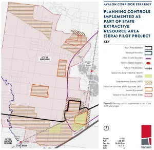
- The formal gazettal of the pilot project into the Wyndham Planning Scheme has resulted in new planning controls in the form of the State Resource Overlay (SRO) being applied over the identified land, as shown in Figure 5.
- CoGG’s Industrial Land Supply Report (2018) concluded there is an adequate supply of zoned and unzoned industrial land stocks to meet current trends and accelerated consumption rates across the municipal area of Geelong. It concluded there is no immediate shortfall of industrial land by specific lot size with an ample availability of smaller lots as well as the ability to service larger industrial users if required within the Geelong Ring Road Employment Precinct and Armstrong Creek North East Industrial Precinct.
- The study area is noted to include land formally known as the New Corio Estate. Planning issues associated with this area have previously been considered in detail as part of Amendment C243 which formalised the designation of a Native Vegetation Precinct Plan area associated with the Geelong Ring Road Employment Precinct.
- CoGG’s Rural Land Use Strategy (2007) remains a strategically valid document and provides commentary regarding agricultural land use within the study area. The recommendations of the strategy include reinforcing rural activity and farmed landscapes, while protecting and providing opportunities for productive agriculture.
- The Werribee-Geelong: Planning Investigation of Strategic Intent Developable Land Analysis prepared by GHD (2014) for the former Department of Transport Planning and Local Infrastructure informed the preparation of Plan Melbourne and is relevant to the Avalon Corridor Strategy. This analysis divided the Avalon Corridor into five main investigation areas:
- North Plains - including land north of the Melbourne-Geelong railway alignment
- Central East - including land east of Little River between the Melbourne-Geelong railway alignment and Princes Freeway
- Central West - including land south of Melbourne-Geelong railway alignment between Lara and Little River
- Central Coast - including Melbourne Water land to west of Little River
- Airport Environs - including the current extent of Avalon Airport land.
- Land constituting the larger extent of the Lara and Little River townships and WTP land (east of the Little River waterway) were excluded from the investigation area for the GHD analysis.
- Based on the designated investigation areas, the report provides a high level analysis of the constraints posed by the identified environmental, heritage, planning, infrastructure and other land constraints within the area, and outlines development opportunities for the investigation areas. The study also highlights the role played by the green break between Geelong and Melbourne for landscape, heritage and social values and its implications for development.
- While the significant existing and planned transport infrastructure for the area poses opportunities for development, the report highlighted considerable constraints including biodiversity and conservation values, airport and quarry buffer requirements, odour impact from the WTP, landscape and visual impacts, flooding and drainage issues, and servicing upgrade requirements.
- The report designates land based on three indicators including:
- Land potentially suitable for development
- Further investigation required
- Land unsuitable for development.
- Of note, the majority of land identified as being potentially suitable for development is quite fragmented, with the only larger continuous area being located to the west of Avalon Airport. As this report was based on a desktop assessment of available information, further investigation of development potential is required. The merits of any proposal should be assessed against relevant Planning Scheme requirements.
- In general, the report acknowledges potential for employment and infrastructure development. It does not identify residential development opportunities due to considerable constraints. The report suggests leveraging key infrastructure assets for compatible and complimentary land uses, including industrial and logistical uses in areas subject to noise, odour and height constraints (such as Avalon Airport).
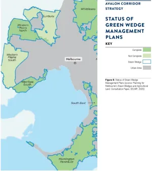
- Green wedge considerations are also relevant to the Avalon Corridor Strategy. Green wedge land has protection under Part 3AA of the P&E Act, which requires any planning scheme amendment to alter or remove controls over GWZ land to be approved by the Minister for Planning and ratified by both Houses of Parliament. In addition to this legislative protection, DELWP are facilitating a major piece of strategic work to better plan for the management and protection of green wedge land.
- DELWP’s Planning for Melbourne’s Green Wedges and Agricultural Land: Consultation Paper (2020) was out for community consultation until February 2021. This project is part of the Victorian Government’s commitment to protecting Melbourne’s green wedge and periurban areas as outlined in Actions 17, 72 and 73 of Plan Melbourne. The project considers agricultural land within 100km from Melbourne and therefore has implications for both CoGG and WCC.
- Land within the Avalon Corridor designated as GWZ is located within WCC. This includes land located outside of the UGB and extending to Little River which forms the municipal boundary between WCC and CoGG.
- The Consultation Paper identifies that while green wedge areas have been largely protected from urban encroachment, existing policy and planning measures are no longer effective. The paper highlighted the following concerns:
- Increased land speculation and pressure to convert farmland to other uses
- Increased appetite for rural lifestyles and use of these areas for a range of urban activities
- Incremental and irreversible loss of land that is agriculturally productive or has important non urban uses
- More land use conflicts, particularly where urban areas adjoin rural areas.
- The Consultation Paper outlined a number of recommendations that aim to deliver lasting protection of agricultural land and guide decision-making on green wedge areas, including:
- Anticipate challenges to agricultural productivity under climate change
- Realise the unique and strategic opportunities afforded by the study area’s unique natural attributes, proximity to Melbourne and infrastructure capabilities
- Protect the special qualities and significant features of the environmental, economic, cultural and health values of the study area for our communities
- Achieve greater certainty and consistency of planning and decision-making across the study area to realise a sustainable future for our growing city and state.
- Strategic land use decisions affecting green wedge land in WCC are further guided by the Green Wedge Management Plans for Werribee South (2016) and Western Plains South (ongoing).
- The Werribee South Green Wedge Management Plan (2016) covers land within WCC located outside of the UGB and south of the Princes Freeway. Land within the Avalon Corridor affected by the Werribee South Green Wedge Management Plan is noted to exclusively fall within the WTP site.
The Western Plains South Green Wedge Management Plan: Background Report (2018), covers a larger area of land within WCC located outside of the UGB to the west and northwest of Werribee. Large areas of this green wedge are located within the Western Grasslands Reserve and have therefore already been identified for long term conservation.
- For other parts of the Western Plains South Green Wedge within the Avalon Corridor, the Background Report raises a range of considerations for further analysis through the development of a draft Green Wedge Management Plan:
- Develop a clear vision, strategic objectives and land use outcomes that reinforces the role and function of the green wedge and UGB.
- Encourage improved interfaces between the green wedge and future urban and infrastructure development to prevent land use conflict and protect visual amenity.
- Consider:
- precincts as a mechanism to acknowledge diversity of landscapes, land uses and values within the green wedge and tailor policy to respond to localised issues and opportunities.
- natural attributes of the land, current land use, strategic directions and preferred land use outcomes including opportunities for agriculture, tourism and recreation.
- a landscape character study of the green wedge including identification of views and viewpoints.
- appropriate planning controls and management measures for sensitive landscape areas on the basis of the landscape character study.
- tourism and recreation opportunities that support protection and enhancement of biodiversity values.
- measures to improve understanding and appreciation of dry stone walls and the role of landholders as custodians.
- opportunities for beneficial reuse of recycled water from the Melton Recycled Water Plant.
- Continue to:
- apply measures that recognise and protect heritage values.
- engage with Traditional Owners in the planning and management of the green wedge.
- apply measures to protect utilities and extractive industry from encroachment by sensitive uses.
- Work closely with VicRoads and relevant agencies to reduce impacts arising from the implementation of road infrastructure including the OMR Transport Corridor.
- The Port Phillip Bay (Western Shoreline) and Bellarine Peninsula Ramsar Site Management Plan (DELWP, 2018) sits within an overarching framework for the management of coastal ecosystems in Victoria and Australia. At the national level, the Environment Protection and Biodiversity Conservation Act 1999 (EPBC Act) establishes the basis for managing Ramsar sites and provides a set of national guidelines for describing ecological character and developing management plans (DEWHA 2008). In Victoria, the Victorian Waterway Management Strategy guides the management of rivers, estuaries and wetlands. The Site Management Plan aligns with Action 3.4 and 3.9 in Water for Victoria by improving waterway health and knowledge of waterways and catchments.
- The primary purpose of the Site Management Plan is to maintain ecological character and promote appropriate land use within the Ramsar site. The site supports a number of environmental, economic, social and cultural values, which need to be maintained. Accordingly, the Site Management Plan aims to ‘maintain, and where necessary improve, the ecological character of the Port Phillip Bay (Western Shoreline) and Bellarine Peninsula Ramsar Site and support wise and sustainable use.’
- CoGG’s Rural Land Use Strategy (2007) (RLUS) provides direction for agricultural land use within the Avalon Corridor. The strategic directions outlined in the Executive Summary (page 4) state that the Rural Land Use Strategy sets out a long term vision for the City’s rural areas that:
- Reinforces a rural, farmed landscape beyond urban areas
- Continues to protect and provide opportunities for productive agriculture – Enhances the condition of the environment and the natural resource base
- Contributes to the ongoing economic prosperity and quality lifestyle of the region.
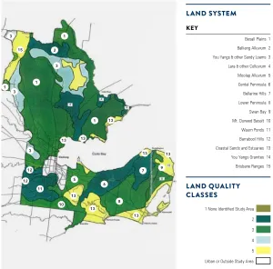
- The RLUS includes an agricultural land quality class map (Diagram 1). Within the Avalon Corridor the following land quality classifications are present:
- Class 2 - high quality agricultural land
- Class 3 - moderate quality agricultural land
- Section 10.8 (Northern area) of the RLUS is relevant to the Avalon Corridor Strategy and notes:
- The northern areas of the City comprise rural landscapes used for cropping, grazing and viticulture
- The You Yangs and Brisbane Ranges are significant landscape features
- Land is largely of Class 3 quality, with some areas of Class 2 quality land
- Land is still largely in parcels of productive size, and there are a number of large properties comprising many parcels of land being farmed.
- The RLUS nominates that land within the Avalon Corridor should be maintained for agricultural use, and development adjacent to the You Yangs should be limited and carefully managed to protect landscape features.
- Section 10.9 Avalon notes that Avalon Airport is a significant state and regional transport facility. Rural and agricultural land near the airport provides potential for intensive horticulture activities and presents significant opportunities for export of high quality produce to domestic and international markets. Such activities should be supported as a part of the agricultural economy of Greater Geelong.
- Recommendations of the RLUS are clear in seeking to reinforce rural activity and farmed landscapes, while protecting and providing opportunities for productive agriculture. Key types of agriculture identified by the RLUS are outlined below:
- Broad acre farming relates to the large scale production of grains and other crops, or the grazing of livestock for meat or wool, on a large scale.
- Intensive farming relates to methods of agricultural production that requires high inputs to maximize productivity of a small piece of land for either crops or animals.
- Dryland farming relates to the cultivation of crops without irrigation in regions of limited moisture, typically less than 50 centimetres of precipitation annually.
- Irrigation farming relates to the agricultural process of applying controlled amounts of water to land to assist in the production of crops, as well as to grow landscape plants and lawns.
- Greenhouse farming relates to the farm practice of growing crops within sheltered structures covered by a transparent, or partially transparent, material. The main purpose of greenhouses is to provide favourable growing conditions and to protect crops from unfavourable weather and pests.
- Agricultural viability within the study area is noted to be moderate to high based on the RLUS. There is also potential for alternate forms of agriculture such as greenhouse farming to be contemplated. However, this form of farming is generally not supported by the community for amenity reasons, and could impact the broader rural landscape character of the Avalon Corridor. If greenhouse farming is pursued within the Avalon Corridor, siting and design considerations would be of critical importance.
- There are opportunities to consider potential use of recycled water within the Avalon Corridor from the WTP (Melbourne Water), Northern Treatment Plant in Corio (Barwon Water) and Melton Recycled Water Plant (Greater Western Water). Currently, the production of recycled water is not cost-effective. However, recycled water may become more financially viable in the future through technical advancement or Government investment, incentives and subsidies.
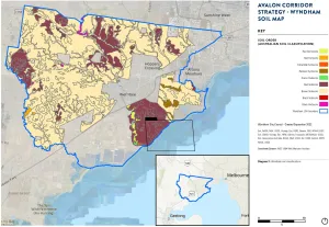
- The soil profile of the Avalon Corridor aligns with the Newer Volcanics Province, which extends from the west of Melbourne to Mount Gambier. The underlying bedrock is generally characterised by basalts and lavas, with later sedimentary units around waterways and the coastline. Ongoing quarrying activities in the area have also created deposits south of the Princes Highway.
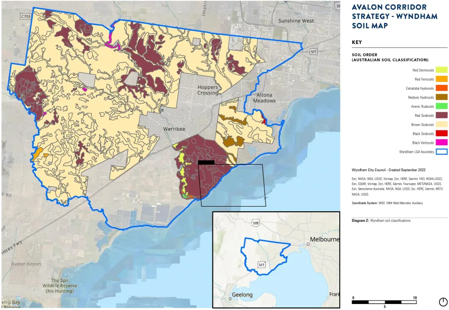
- Due to the underlying geology, soils in WCC vary across the municipality with Brown Sodosols being the most common unit (Diagram 2). Red Sodosols are also present within localised areas of WCC, such as the Werribee Irrigation District. Sodic soils contain high levels of sodium and can be challenging to manage due to their chemistry, structure and behaviour in wet and dry environments. Areas containing sodic soils within WCC and the wider Avalon Corridor require ongoing management of erosion and soil stability, as well as flow on impacts on surrounding natural systems.
A range of planning policies are relevant to the Avalon Corridor Strategy, including the State Planning Policy Framework (PPF) and the Local PPF contained in both the Wyndham and Greater Geelong Planning Schemes. A summary of relevant planning policies at both State and municipal level are outlined below.
Plan Melbourne (2017) contains a number of directions, policies, principles and outcomes of relevance to the Avalon Corridor. It identifies Avalon Airport and the proposed Bay West Port as a state significant transport gateways and recognises the need to secure adequate capacity for moving passengers and freight into and out of Victoria. Plan Melbourne also supports future employment and economic development opportunities at major ports, airports and interstate terminals, noting the need to protect these assets from incompatible land uses.
Policies
- Policy 1.1.5 Support major transport gateways as important locations for employment and economic activity - speaks specifically to designated ports, and airports and acknowledges the Bay West Port as a possible seaport within the Avalon Corridor. This policy seeks to ensure that land around state-significant transport gateways are protected from incompatible land uses to ensure they keep generating economic activity and new jobs.
- Policy 1.1.6 Plan for industrial land in the right locations to support employment and investment opportunities - highlights the economic contribution of industrial land, the need to protect existing industrial land from incompatible land uses to allow for future growth, and to identify strategic locations for major development linked to the Principal Freight Network and transport gateways and networks. The Plan Melbourne 2017-2050 Addendum 2019 recognises Avalon Airport as a transport gateway and identifies the Avalon Rail Link and the Western Rail Plan as potential transport infrastructure improvements.
- Policy 3.4.1 Support sufficient gateway capacity with efficient landside access - seeks to evaluate appropriate locations for Victoria’s second container port and also speaks to the importance of the WIFT and Avalon Airport.
- Policy 4.5.1 Strengthen protection and management of green wedge land - identifies the Avalon Corridor as being partially within a green wedge area (Western Plains South) and a peri urban area and seeks to protect GWZ areas from inappropriate land use and development.
- Policy 7.2.2 Strengthen transport links on national networks for the movement of commodities - specifically refers to the Avalon Corridor, noting:
Victoria’s economy depends on its ability to move goods between state-significant places (such as regional cities and Melbourne) and to interstate and international markets. Transport network planning must ensure that industries such as Victoria’s food and fibre industry remain viable and competitive. This should include identification of key freight corridors and interstate freight terminals. For example, the Avalon corridor near Geelong contains nationally significant economic assets, including airport, road, rail and waste facilities. This corridor must be safeguarded for state infrastructure opportunities and complementary development in the future, as well as maintaining a settlement break between Melbourne and Geelong. Land use buffers for infrastructure and Avalon Airport and areas of high biodiversity value, including Ramsar conservation areas, must be protected.
Principles
- A globally connected and competitive city - relates to developing and delivering on infrastructure to support competition across different sectors
- Environmental resilience and sustainability - relates to the protection of biodiversity and natural resources
- A city of centres link to regional growth - relates to physical, social and economic connections between Melbourne and regional areas
Outcomes and directions
| Outcome | Direction |
|---|---|
| Outcome 1 Melbourne is a productive city that attracts investment, supports innovation and creates jobs | Direction 1.1 Seeks to strengthen competitiveness of the economy and direction 1.4 seeks to support the productive use of land in non-urban areas |
| Outcome 3 Melbourne has an integrated transport system that connects people to jobs and services and goods to market | Direction 3.4 Seeks to improve freight efficiency and increase capacity of gateways while protecting urban amenity |
| Outcome 4 Melbourne is a distinctive and liveable city with quality design and amenity | Direction 4.5 Seeks to protect green wedges and periurban areas |
| Outcome 6 Melbourne is a sustainable resilient city | Direction 6.5 Seeks to protect and restore natural habitats, this is relevant due to the Avalon Corridor’s environmentally significant sites |
| Outcome 7 Regional Victoria is productive, sustainable and supports jobs and economic growth | Direction 7.2 Seeks to improve connections between cities and regions |
Implementation
Plan Melbourne includes a separate implementation plan with short, medium and long term actions.
- Action 17 Support strategic planning for agriculture seeks to ‘improve planning decisionmaking to support sustainable agriculture by identifying areas of strategic agricultural land in Melbourne’s green wedges and peri-urban areas. This will give consideration to climate change, soils and landscape, access to water, integration with industry and significant government investment in agricultural infrastructure.’
- Action 18 Management of extractive industry seeks to ‘protect the extractive industry and future extractive-resource assets from incompatible land uses by adopting planning options consistent with the findings of the Extractive Resources in Victoria, Demand and Supply Study, 2015–2050.’
- Action 48 Strategy for future gateways seeks to ‘protect options for future air and sea ports and intermodal terminals through appropriate planning frameworks.’
- Action 72 Review green wedge planning provisions seeks to ‘review green wedge planning provisions to ensure they support Plan Melbourne outcomes for green wedges.’
- Action 73 Green Wedge Management Plans seeks to ‘support local government to complete and implement green wedge management plans to protect and enhance the agricultural, biodiversity, environmental, natural resource, tourism, landscape and other values of each of Melbourne’s green wedges.’
- Action 74 Localised planning statements for distinctive areas and landscapes seeks to ‘prepare localised planning statements for other distinctive areas within Melbourne’s green wedges and peri-urban areas.’
- Action 95 Environmental protection for coastlines and waters of Port Phillip Bay and Western Port seeks to ‘improve environmental protection for Melbourne’s coasts and the waters of Melbourne’s bays through local planning schemes.’
The PPF is contained in all Victorian Planning Schemes and include policies that relate to the use and development of land throughout Victoria. The PPF covers issues of state importance that address settlement planning, residential development, environmental and landscape values, natural resource management, built environment and heritage, housing, economic development, transport and infrastructure, in addition to more specific regional focused policies.
Beyond the overarching Plan Melbourne strategy, there are a number of Regional Strategic Plans embedded into Clause 11 - Settlement. The regional Development Plan relevant for the CoGG is the G21 Regional Growth Plan directly referenced at Clause 11.01-1R - Geelong (G21).
Further relevant policies of the PPF are listed in Appendix 1.
The PPF at a local level includes two key sections, including: the Municipal Planning Strategy (MPS) and local planning policies. The MPS sets out the vision documents for Council. Within the Wyndham Planning Scheme, the MPS acknowledges expected increases in population growth and sets out key strategies for settlement planning, land use direction, environmental protection, economic development, transport, infrastructure and landscape values.
In relation to the Avalon Corridor, the MPS places an importance on safeguarding areas of environmental significance and landscape value (with specific mention to the Ramsar sites), maintaining the green break between Werribee and Geelong, diversifying the local economy, supporting integrated transport networks and providing for increased industrial land development opportunities.
Relevant Clauses within the Wyndham MPS include:
- Clause 02.03-1 Settlement – Little River includes strategic directions to provide for limited consolidation in the Little River area, subject to resolution of airport noise from Avalon Airport, infrastructure constraints and development of a township plan; and to Manage the development of Little River to avoid overdevelopment, protect adjoining rural precincts from development impacts and prevent further expansion of the township into the surrounding rural precincts.
- Clause 02.03-1 Settlement – Green Wedges includes the strategic direction to protect Wyndham’s Green Wedges from inappropriate development and urban intrusion. Broadly it seeks to protect green wedges from inappropriate development, retain biodiversity values, and encourage compatible rural uses.
- Clause 02.03-2 Environmental and landscape values contains objectives to protect and restore biodiversity and natural habitats; to protect Wyndham’s natural environment and landscape with respect to growth, land use and the impacts of climate change; to protect and enhance the distinctive sense of place, cultural identity and landscape within the growth areas of Wyndham; to manage urban encroachment on the coast and its impacts on environmental values along the coast.
- Clause 02.03-3 Environmental risks and amenity contains objectives to promote environmental sustainability through built form, urban infrastructure and consolidation; to apply the ‘precautionary principle’ when planning for the City to help avoid serious or irreversible climate change effects; to minimise the City’s contribution to climate change and gas emissions and minimise the impacts of climate change on Wyndham’s natural and built environment; to protect the community from the economic, social and environmental risks associated with flooding; to ensure that new use and development include adequate fire protection measures.
- Clause 02.03-4 Natural resource management contains objectives to minimise the loss of productive agricultural land and the impacts of incompatible uses on farming operations; to protect the Werribee South market gardens as an area of State agricultural significance; to support the role of rural areas beyond the Urban Growth Boundary to protect and restore biodiversity and viable future rural land uses; and to protect waterways, aquatic areas, wetlands, swamps, catchments, riparian land and waterway valleys.
- Clause 02.03-7 Economic development contains objectives to provide sufficient land to attract investment and generate additional jobs, and to promote Wyndham as a place for long term business attraction and expansion.
- Clause 02.03-8 Transport contains relevant objectives to: provide improved and accessible transport options, and to maintain and enhance existing road infrastructure.
Local planning policies contained in the Wyndham Planning Scheme provide more specific policy direction in relation to neighbourhood character, amenity associated with non-residential development, telecommunications, advertising signage, heritage and electronic gaming machines. It is noted that none of these local policies have particular relevance to the scope of the Avalon Corridor Strategy.
The PPF at a local level includes two key sections: the Municipal Planning Strategy (MPS) at Clause 02 and local components of planning policies at Clauses 11 to 19. At Clause 02.02 the MPS sets out the overarching vision for Greater Geelong: Geelong, coast, country and suburbs, is the best place to live through prosperity and cohesive communities in an exceptional environment.
Relevant Clauses within the Greater Geelong MPS include:
- Clause 02.03-1 Settlement provides strategic direction for settlement growth in Greater Geelong, particularly directing and containing residential growth within identified areas of the municipality, and limiting rural living developments to existing zoned land. With respect to Lara, this clause notes that the Avalon Airport and nearby land provide significant opportunities for employment and economic growth and includes a direction to protect and enhance key environmental, cultural and landscape features, including the rural characteristics of Lara.
- Clause 02.03-7 Industry notes the need to provide support for ongoing employment and economic development in the Geelong region and the need to support industry through the maintenance and improvement of infrastructure including roads, rail and Avalon Airport. The clause provides strategic directions to:
- Provide an adequate supply of industrial land that meets the needs of different industries.
- Focus new industrial development around major transport routes and infrastructure assets.
- Encourage the growth of new and economically sustainable industry sectors.
- Provide a diverse range of high quality industrial and commercial land.
- Clause 02.03-8 Transport notes that Avalon Airport is a major economic and tourism asset to the region and includes a direction to protect and enhance the role of the Avalon Airport, including its expansion options and ongoing technical viability and operational requirements.
- Clause 02.03-2 Environmental and landscape values
The Local Planning Policy Framework (Clauses 11 to 19) also includes various policies relevant to the Avalon Corridor, including:
- Clause 11.01-1L-01 Settlement – Greater Geelong
- Retention of the rural landscape setting including views to the You Yangs.
- Protection of agricultural land, particularly to the north of Lara and aquaculture or intensive agricultural production activities adjacent and complementary to Avalon Airport.
- Protection of opportunities for a potential intermodal transport facility [With regard to the ‘potential intermodal transport facility’, the Lara Structure Plan Map contained in Clause 11.01-L-03 Lara clarifies this to be to the northeast of the township and between the Melbourne/ Geelong railway alignment and Old Melbourne Road].
- Protection of the current and future operations and development of Avalon Airport including associated or compatible uses.
- Clause 14.01-1L-02 Dwellings and subdivision in farming areas
- An objective to ensure that the development of dwellings and excision of existing dwellings are consistent with the use of land for sustainable rural uses. – A strategy to discourage house lot excisions.
- A strategy to support construction of a dwelling where:
- The dwelling will not result in the property being removed from agricultural production and the primary use of the land will continue to be agriculture.
- Existing agricultural activity on adjoining land will not be compromised.
- The proportion of the property used for the dwelling and ancillary infrastructure is minimised and located on the area of lowest agricultural quality.
- Clause 17.01-1L-01 Diversified economy – Greater Geelong
- Support the development of seafood and aquaculture industries, particularly in North Geelong, Portarlington and Avalon.
- Support the development of aerospace industries within the confines of the Avalon Airport site.
- Clause 17.04-1L-02 Tourism in rural areas
- Support tourism uses associated with an agricultural activity on the land.
- Discourage tourism uses not associated with an agricultural activity on the land unless specified criteria apply.
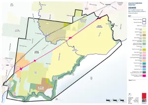
A variety of zones are applied in the Avalon Corridor through the Greater Geelong and Wyndham Planning Schemes. The largest single zone within the Avalon Corridor is the Public Use Zone (PUZ) which applies to the WTP, followed by the Green Wedge Zone (GWZ) within WCC and the Farming Zone (FZ) predominantly found within CoGG.
Both the GWZ and FZ seek to limit development and maintain larger lots for rural and related activities, which is further articulated through relevant state and local policies of the PPF. The result of such zones and policies is that land within these areas is relativity free of development and generally maintains larger lot sizes and an open landscape rural character.
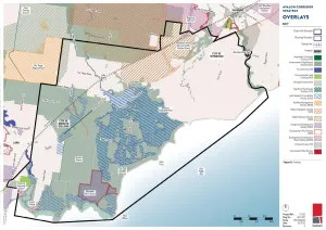
A summary of the applicable zones and overlays is provided below and in Figures 7 and 8.
Public Use Zone
The Public Use Zone (PUZ) recognises public land use for community services and facilities. It applies to publicly owned land and includes a variety of uses as outlined in the relevant Schedule.
- PUZ1 applies to land containing services and utilities. Within the Avalon Corridor, this includes the WTP, which extends across both Wyndham and Geelong municipality.
- PUZ2 applies to land used for education. In the Avalon Corridor this relates to Little River Primary School.
Transport Zone
The Transport Zone (TRZ) seeks to provide for an integrated and sustainable transport system, and applies to land previously controlled by the PUZ. Land within the Avalon Corridor is allocated for state transport infrastructure (TRZ1 – regional railway), principal road network (TRZ2 – Princes Highway and intersections) and significant municipal roads (TRZ3).
Special Use Zone
The Special Use Zone (SUZ) applies to sites that have been developed or used for a specific purpose that is listed within the relevant Schedule. The SUZ includes areas that are within the Port Phillip (Western Shoreline) and Bellarine Peninsula Ramsar site. The Ramsar site needs to be taken into consideration in any planning or development proposals, given it is a matter of national environmental significance under the Environment Protection and Biodiversity Conservation ACT 1999.
- SUZ6 in the Wyndham Planning Scheme relates to the Earth and Energy Resource Industry and provides for the operation of a number of quarry sites, both active and approved, including the Wyndham RDF and Holcim Quarry, the Holcim extractive industry site adjacent to the west and the proposed extractive industry site to the north.
- SUZ1 in the Greater Geelong Planning Scheme relates to Environmental Wetlands, Salt Production and Land Based Aquaculture Activities, and applies to the former Cheetham Saltworks site west of Avalon Airport.
- SUZ11 in the Greater Geelong Planning Scheme relates to the Avalon Airport precinct and contains the following specific purposes:
- To provide for:
- an operational airport and associated activities.
- a range of employment generating land uses which do not adversely interfere with the operation of the airport.
- use and development that facilitates the vision and development objectives contained in any approved Master Plan for the airport.
- a range of commercial, industrial and retail facilities which add to the diversity of economic generating activities.
- To ensure:
- the use and development of the site are compatible with existing uses in the vicinity.
- that land uses have consideration of environmental attributes of the area.
- To provide for:
Industrial 2 Zone
The Industrial 2 Zone (I2Z) applies to the Mountain View Quarry Site and surrounds. The I2Z prioritises land to be available for heavy industry which requires substantial buffers, as articulated within the relevant zone purposes:
- To provide for manufacturing industry, the storage and distribution of goods and associated facilities in a manner which does not affect the safety and amenity of local communities.
- To promote manufacturing industries and storage facilities that require a substantial threshold distance within the core of the zone.
- To keep the core of the zone free of uses which are suitable for location elsewhere so as to be available for manufacturing industries and storage facilities that require a substantial threshold distance as the need for these arises.
Public Park and Recreation Zone
The Public Park and Recreation Zone (PPRZ) applies to publicly owned land that provides community facilities. Within the Avalon Corridor this relates to land on the north-eastern border next to the Werribee River and also adjacent to the Little River watercourse.
Public Conservation and Resource Zone
The Public Conservation and Resource Zone (PCRZ) applies to land south-west of the WTP along the coastline including the Spit Wildfire Reserve. The PCRZ provides for the protection of environmentally sensitive landscape while also allowing for some nature based recreation activities or accommodation.
Rural Conservation Zone
A small portion of the study is affected by the Rural Conservation Zone (RCZ), to the north of the railway adjacent to the Wyndham RDF. The RCZ identifies land of high environmental value and aims to protect the land from inappropriate urban encroachment and agricultural use. RCZ within the Avalon Corridor is associated with the Western Grasslands Nature Conservation Reserve that forms part of the Melbourne Strategic Assessment (MSA) area.
Low Density Residential Zone
Land zoned Low Density Residential Zone (LDRZ) within the Avalon Corridor exists on the outskirts of Little River township. The LDRZ is a residential zone that provides for dwellings to be built on lots as small as 0.4 hectares.
Green Wedge Zone
The GWZ only applies to land within Wyndham and seeks to recognise, protect and conserve green wedge land for its agricultural, environmental, historic, landscape, recreational and tourism opportunities, and mineral and stone resources. GWZ land within the Avalon Corridor is located north of the alignment of the Little River watercourse, extending broadly north to the Avalon Corridor boundary.
Rural Living Zone
Rural Living Zone (RLZ) land within the Avalon Corridor is located on the edge of Lara, both north and south of the Princes Freeway. The RLZ is a residential zone that provides for small scale hobby farming and dwellings on lots no smaller than two hectares.
Farming Zone
The FZ applies to a small portion of land within Wyndham, to the north east of the Avalon Corridor around the Wyndham RDF and Holcim Quarry. A much larger portion of FZ land is located within CoGG, including land north of the Princes Freeway extending from Lara through to Little River, as well as land south of the Princess Freeway to the west of Avalon Airport. The purpose of the FZ is to prioritise and protect agricultural uses, but also allow complementary activities such as tourism. Minimum lot sizes apply to subdivision and development within FZ land:
- CoGG: 80 hectare minimum lot subdivision and for an area for which no permit is required to construct a dwelling; and
- Wyndham: 40 hectare minimum lot subdivision and for an area for which no permit is required to construct a dwelling.
A variety of overlays are applied to the Avalon Corridor through the Greater Geelong and Wyndham Planning Schemes.
Land Subject to Inundation Overlay
The Land Subject to Inundation Overlay (LSIO) is a floodway overlay aimed to ensure the protection of water quality and reduce the impact of development. It also aims to ensure that the free passage and flow of floodwaters is not restricted. The LSIO affects only land located within CoGG, including land within Avalon Airport and the WTP, as well as land north of the Princes Freeway between Lara and Little River.
Environmental Significance Overlay
The Environmental Significance Overlay (ESO) serves to ensure that development “is compatible with identified environmental values.” Land within CoGG is affected by ESO2 and ESO4, while land in Wyndham is affected by ESO1, ESO4 and ESO5. Each Schedule sets out the permit triggers and environmental objectives to be achieved on affected sites.
- ESO2 in Greater Geelong relates to “High Value Wetlands and Associated Habitat Protection” and applies broadly along the coastal environs and the WTP land within the CoGG.
- ESO4 in Greater Geelong and ESO5 in WCC were introduced to protect areas of Natural Temperate Grassland of the Victorian Volcanic Plain – a critically endangered ecological community and matter of national environmental significance. The presence of ESO4 and ESO5 represents a significant commitment and obligation of the Victorian Government to secure grassland protection outcomes.
- ESO1 in Wyndham relates to “Waterway Corridors” and applies to narrow sections of land along the Werribee River, Cherry Creek and Lollypop Creek.
- ESO4 in Wyndham relates to the “Western Grasslands Reserve” and applies to a band of land along the northern boundary of the Avalon Corridor. This overlay functions to recognise and protect grasslands through the creation of a grasslands reserve.
Environmental Audit Overlay
The Environmental Audit Overlay (EAO) identifies land where there is a potential risk of contamination due to previous land use, and applies to a small area of land to the south west corner of the Avalon Corridor within Wyndham.
Heritage Overlay
- The Heritage Overlay (HO) identifies land or precincts with heritage significance. Five overlays exist for places of state historical significance on the Victorian Heritage Register and are subject to the provisions of the Heritage Act (2017):
- Former Metropolitan Farm (VHR H2400)
- Water Tank (VHR H1416)
- Little River Railway Station and Goods Yard (VHR H1572)
- Hume and Hovell Memorial (VHR H1547)
- Rothwell Bridge (VHR H1454)
Outside the townships of Lara and Werribee, there are 29 places of local historical significance, which are subject to specific HO controls. 16 of these occur within the township of Little River (13 building features, two riverside reserves, and the Grant Bridge), with six further rural places and three remnant networks of drystone walling along road and paddock boundaries in the area north of Little River. All of the preceding places occur within Wyndham. Two further rural places associated with the Avalon College and Geelong Grammar occur within CoGG adjoining Limeburners Bay. Dry stone walls within the CoGG area between Little River and Lara are subject to generic protection under the Greater Geelong Planning Scheme rather than individual HOs.
Beyond these specific sites, there are other numerous elements of historical interest within the study area. These include 23 sites on the Victoria Heritage Register/Victorian Heritage Inventory (VHI) that are the subject of archaeological permits under the Heritage Act. These places are predominantly ruins or minor surface features associated with past rural and marine/ coastal activities. A specific area of historical interest includes the historical crossing place of the Old Melbourne Road over the Little River at Rothwell, with the Travellers Rest Inn ruin and other potential archaeological features in the vicinity
Heritage Overlays are evolving. Municipal heritage studies undertaken by CoGG and a Heritage Review (Gap Study) undertaken by WCC in 2019 have identified a number of historical sites that have the potential to meet the threshold for protection under a HO. Both Councils are proposing to undertake further investigation of these over the next five years.
Development Plan Overlay
The Development Plan Overlay (DPO) identifies areas where a development plan has been prepared specific to that land to guide future land use and development. DPO1 in CoGG applies to the ‘Special Industrial Area, Point Wilson’. The Schedule further clarifies the intent of the overlay with the following statement:
This schedule applies to the Industrial 2 zone located in Dandos Road, Point Wilson. Whilst this land has not been developed apart from an existing quarry operation, the zoning of the land recognises its potential as a site for a large scale industrial development requiring substantial buffer distances. A development plan is required to ensure that the area’s environmentally significant flora and fauna is protected and that all planning issues are fully addressed prior to the issue of a permit for the development of the land.
Design and Development Overlay
The Design and Development Overlay (DDO) provides specific design and built form requirements to land. DDO20 is a CoGG specific schedule that applies to all Industrial 1, 2 and 3 Zone land within the municipality.
Public Acquisition Overlay
The Public Acquisition Overlay (PAO) affects land that has been designated for a future project and will need to be acquired.
- PAO14 applies within CoGG and relates to land put aside for train infrastructure associated with the alignment of the potential Avalon Airport Rail Link.
- PAO5 applies to land within Wyndham and relates to land designated to accommodate the OMR/E6 Transport Corridor.
- PAO10 in CoGG also relates to the OMR/E6 Transport Corridor.
- Although located outside of the study area, PAO11 in CoGG and PAO7 in Wyndham relate to the Western Grasslands Reserve.
Vegetation Protection Overlay
The Vegetation Protection Overlay (VPO) affects land with identified significant vegetation and aims to prevent further loss. VPO1 is located within CoGG and relates to “Significant Roadsides and Linear Reserves”, including sections of Sandy Creek Road and Gillets Road.
Significant Landscape Overlay
The Significant Landscape Overlay (SLO) affects land identified to contain significant landscape character values. SLO1 affects a small portion of the north western corner of the Avalon Corridor within CoGG and relates to the protection of the foothills of the You Yangs (located immediately outside of the Avalon Corridor to the west).
State Resource Overlay
The State Resource Overlay (SRO) affects land within Wyndham, and functions to protect areas of mineral, stone and other resources that have been identified as being of state significance from use and development that would prejudice the current or future productive use of the resource. Land within the Avalon Corridor affected by the SRO consists of large areas to the west of Werribee and to the north of the Princes Freeway.
Two schedules to the SRO apply within Wyndham:
- SRO1 (Strategic Extractive Resource Areas) – applies to land within Wyndham known as SERAs. These are locations with a state-significant supply of hard rock resources, and where future investment in extractive industries is encouraged.
- SRO2 (Protecting Extractive Industries) – applies a 500 metre separation distance around land that contains a work authority issued under the Mineral Resources (Sustainable Development) Act (1990).
These Schedules ensure that new uses and developments do not inhibit current or future productivity of existing extractive industry operations, or the potential future establishment of extractive industry operations within SERAs.
Based on the review of strategic land use studies and planning policies, the key strategic considerations for the Avalon Corridor are:
- Management of ongoing airport activities, and facilitation of major future expansion to a full scale international airport.
- Potential for substantial economic activity in and around Avalon Airport for compatible land uses such as commercial, industrial, agricultural and tourism.
- Safeguarding land for the expansion and development of major state infrastructure projects such as the OMR Transport Corridor and Bay West Port.
- Limitations on residential development into important non-urban land, as identified through the GWZ and other policy.
- Importance of environmental protection for key flora, fauna, ecological communities and habitats such as the Western Grasslands Reserve and Ramsar site.
- The importance of protecting and managing identified EIIAs and SERAs within the Avalon Corridor.
To further summarise the desktop analysis, matters of strategic influence to the Avalon Corridor also include:
- Various planning policies and strategies - which reinforce a physical green break between the outer edge of metropolitan Melbourne (Werribee) and Geelong, including the Western Grasslands Reserve.
- The possible Avalon Airport Rail Link - which is safeguarded through PAO14 in the Greater Geelong Planning Scheme.
- The OMR Transport Corridor - which is incorporated within the Wyndham Planning Scheme and has an indicative timeframe of completion within 15-30 years.
- The WIFT - which is currently under investigation, with Infrastructure Victoria indicating up to 5 years for finalising planning and 10-30 years for construction.
- Bay West Port - which has been nominated by Infrastructure Victoria as the preferred location for the Melbourne’s second container port terminal and is targeted for operations from around 2055.
- The Western Treatment Plant (WTP) - Melbourne Water is investigating options for increased community access to select areas through regional cycling path connections, bird watching and ecotourism opportunities that are compatible with the site’s primary purpose and environmental values.
- Avalon Airport - acknowledged as a significant land use and economic, employment and tourism generating asset for the region.
- West Growth Corridor Plan - which includes the Mambourin East and Werribee Junction Precinct Structure Plans (PSPs). These PSPs are designated for primarily industrial and related activity. These future industrial areas will be influenced by and have an influence on future activities within the Avalon Corridor.
- East Werribee National Employment and Innovation Cluster (NEIC) - although the status and potential timing for future development of the NEIC are unknown, it remains of contextual relevance given the site is located just outside the Avalon Corridor and will be guided by the East Werribee Employment Precinct PSP.
- Avalon Airport Master Plan (2015) - which was endorsed by the Commonwealth Department of Defence in 2015 and sets out the long term vision of the expanded operations of the airport over the next 20 years. While this Master Plan sits as a reference document within the Greater Geelong Planning Scheme, updates to the Avalon Airport Master Plan are ongoing. Further work is required to secure ongoing operations (both current and future) and protect the option for a third cross runway. This will require further protections within the relevant Planning Schemes (both Greater Geelong and Wyndham).
- Lara Structure Plan (2011) - which guides any future development and land use change within the Lara township.
- Little River - while Little River does not have a Structure Plan, it is constrained by a number of surrounding land uses and other considerations including Avalon Airport, WTP and existing zoning.
- Land use buffers - for sites such as WTP, Wyndham RDF, Holcim Quarries (WA184 and WA420), Mountain View Quarry (WA41) and an approved extractive industry site south of Little River (WA980). Specific buffer analysis identified that potential odour impact arising from landfill operations is the most important consideration for setting buffer distances, where sensitive uses are within medium to high risk areas. Specific modelling further determined that areas of medium to high risk of odour may extend beyond the ‘default’ EPA 500 metre buffer distance, although some areas of encroachment would need consideration through later PSP processes.
- Basalt Dimension Stone Quarry (WA980) - which is located to the north of Avalon Airport and was granted permission to develop a new materials recycling facility on site through Planning Permit PP-852-2015 issued by CoGG.
- Point Wilson Munitions Facility - depending on the types of munitions to be stored by the Department of Defence in future, buffers distances may be required once the facility is fully operational. Early advice indicates that an ‘Outer Explosive Ordnance Safety Arc’ of 1.5 to 2.0 kilometres should be maintained.
- Industrial land supply - although considerable supply in Greater Geelong was identified in the 2018 study, there is a lack of land to accommodate large scale industrial uses requiring buffer zones of 1 kilometre from sensitive uses.
- Wurdi Youang / the You Yangs - as a prominent landscape feature and visual backdrop, as well as a site of cultural significance. Limited protection for the foothills of the You Yangs is currently offered by SLO1.
- EIIAs, WAs and SERAs - a number of extractive industry values and operating quarries are present in the Avalon Corridor. These are protected through different planning and land use controls.
- GWZ and peri-urban land - the Victorian Government is undertaking strategic planning work to strengthen the role of Melbourne’s green wedges and wider peri-urban areas. This work underpins the intent of the Avalon Corridor Strategy to protect and reinforce the green break between Melbourne and Geelong.
- Melbourne Sewerage Strategy (2018) - a 50-year strategy developed by Melbourne Water, Greater Western Water, South East Water, Western Water and Yarra Valley Water, which outlines how the sewerage system needs to be transformed into a resource recovery system to enhance its contribution to public health, the environment and affordable essential services.
- Water for Life - a 50-year strategy under development by Melbourne Water, Greater Western Water, South East Water, Western Water and Yarra Valley Water, which seeks to provide a secure water future for Greater Melbourne and build system resilience and manage future climate variability.
- Flood risks - which are associated with the low lying coastal wetland interface of the Avalon Corridor. Flood risk will increase as a result of climate change, sea level rise and coastal erosion. It is important to ensure land use and development is compatible with flood risk, to the satisfaction of Melbourne Water as the floodplain management authority
ACS - Diagram 2 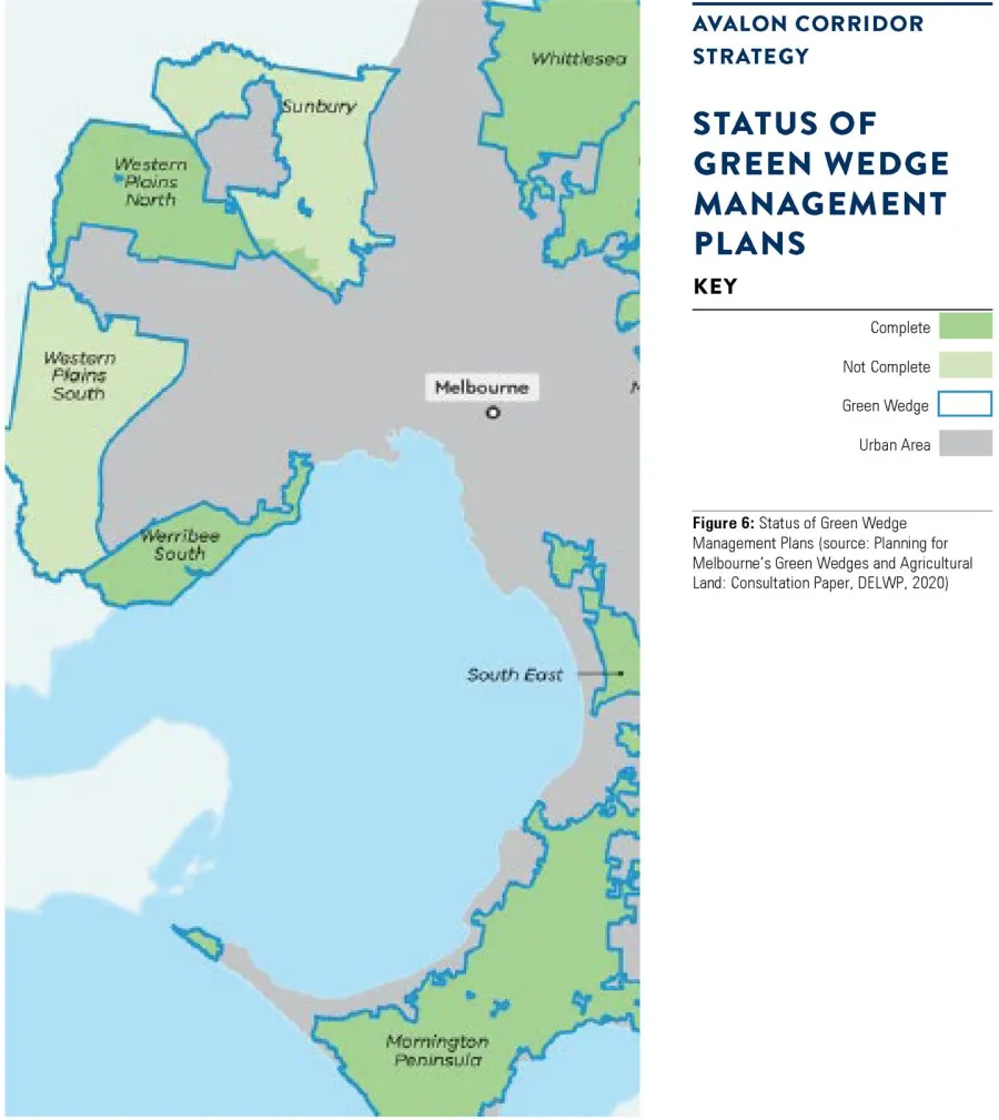
ACS - Figure 6 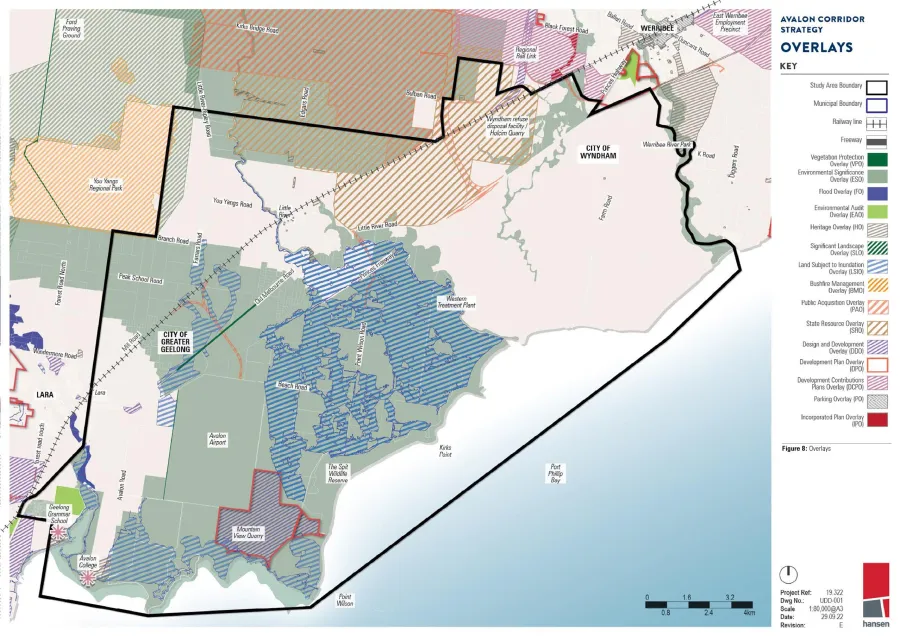
ACS - Figure 8 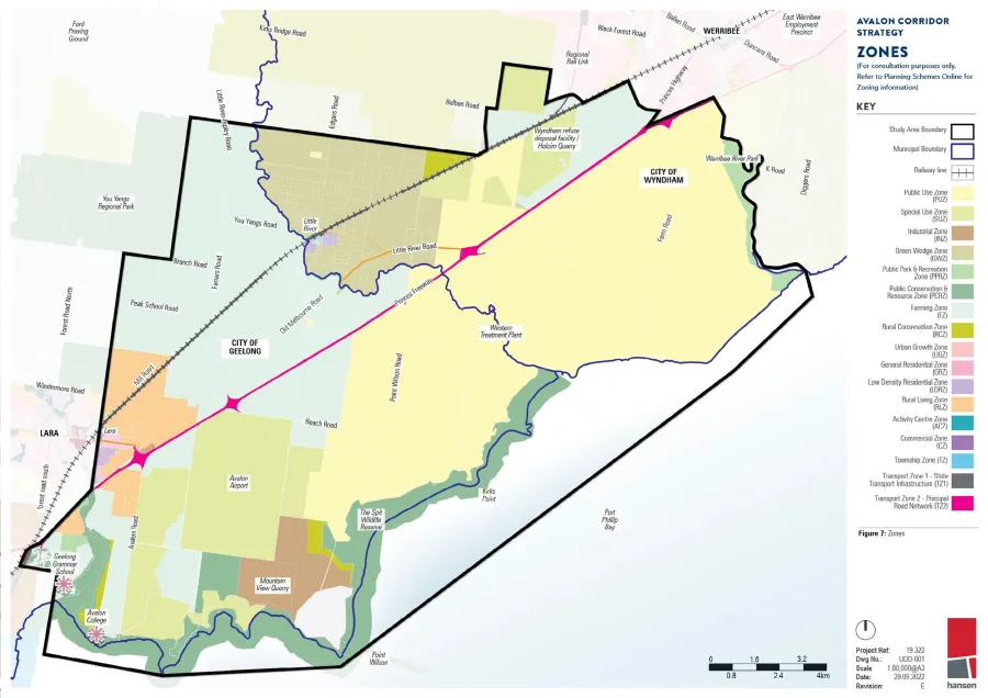
ACS - Figure 7 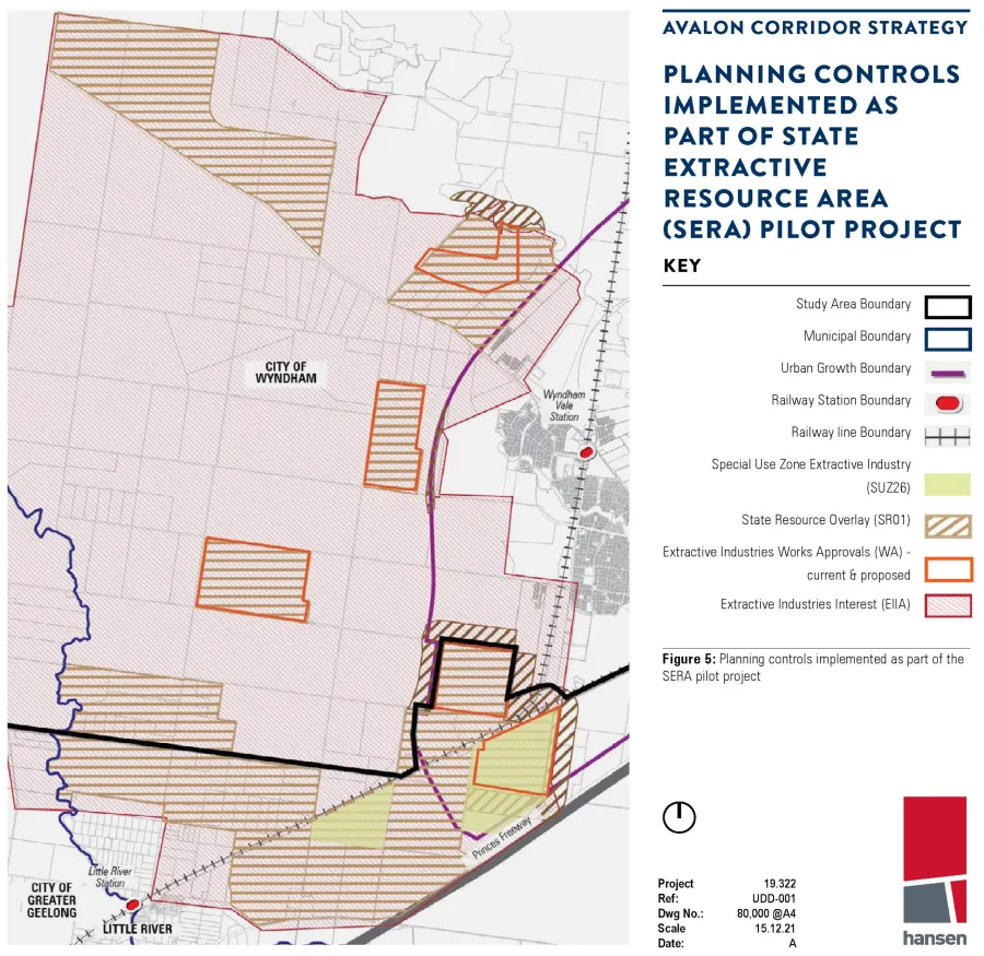
ACS - Figure 5 
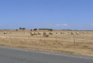
ACS - Open, flat agricultural fields 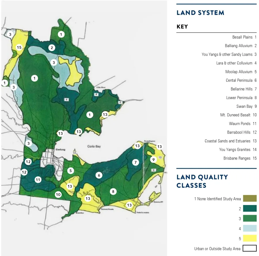
ACS - Diagram 1
Click on an image to view details and enlarge
Page last updated: