To inform preparation of the Avalon Corridor Strategy, GHD prepared a background Servicing Report in 2021.
ACS - Transport analysis
The Servicing Report includes an analysis of transport and utility infrastructure servicing considerations to ensure the early identification of potential issues and opportunities. The report also includes a high level summary of relevant policies and strategies of relevance to the Avalon Corridor. This section contains a summary of key transport considerations from the GHD Servicing Report.
Key transport policies and strategies of relevance to the Avalon Corridor include:
- Delivering the Goods: Victorian Freight Plan (Victorian Government 2018)
- Outer Metropolitan Ring/E6 Transport Corridor Planning Assessment Report (VicRoads 2009)
- G21 Regional Growth Plan (G21 2013)
- Avalon Airport Master Plan (Avalon Airport 2015)
- Extractive Resources in Victoria: Demand and Supply Study 2015-2050 (PWC 2016)
- Victoria’s 30-Year Infrastructure Strategy (Infrastructure Victoria 2016)
- Preparing Advice on Victoria’s Future Port Capacity: Discussion Paper (Infrastructure Victoria 2016)
- Second Container Port Advice - Evidence Base: Discussion Paper (Infrastructure Victoria 2017)
- Avalon Airport Ground Transport Plan (Avalon Airport 2017)
- Helping Victoria Grow: Extractive Resources Strategy (DEDJTR 2018)
- Western Rail Plan (Victorian Government 2018)
- Independent review of the Victorian Ports System (Victorian Government 2021)
The Princes Freeway is the key piece of road infrastructure in the Avalon Corridor. It is controlled and managed by the DoT as the only declared road within the study area. The Princes Freeway is the major transport link between Melbourne and Geelong generally comprising a three lane carriageway in each direction (six lanes in total). The Princes Freeway is a link to many key features within and beyond the Avalon Corridor including:
- Avalon Airport
- Western Treatment Plant (WTP)
- Point Wilson Defence Facility
- You Yangs Regional Park
- Werribee Regional Park
- Werribee Open Range Zoo
- A number of operating and planned quarries
- Townships of Lara and Little River
There are currently no major upgrade plans for the Princes Freeway between Geelong and Werribee. However there is future provision for the addition of an extra lane in each direction should this be required.
The Princes Freeway is susceptible to flooding in the section running over the Lollypop and Skeleton Creek catchments following the equivalent of a 1-in-30-year rain event. There is not currently a mitigation strategy for flood events though DoT have indicated that possible future raising of the road would be preferred over realignment. The frequency and severity of flood events is expected to increase in future years as climate change and sea level rise impact on the ability of the catchment to drain to Port Phillip Bay.
Closures to the Princes Freeway occurred in 2018 during the Little River fires. These closures highlight a lack of resilience and alternate route options that exists in the case of unplanned closure. The only workable alternative is to re-route traffic via Bacchus Marsh. There are no state government plans at present to develop an emergency by-pass route.
The Outer Metropolitan Ring (OMR) Transport Corridor provides an opportunity for the investigation of rail connections in the short to medium term and orbital road and rail traffic solutions around Melbourne in the long term. The entire corridor is around 100 kilometres in length and includes a planned road and rail system that will connect the Princes Freeway through Werribee Melton Tullamarine Craigieburn Mickleham Epping and Thomastown. The current alignment of the OMR was gazetted in 2010 by means of Public Acquisition Overlay (PAO). However further works are required prior to any construction including relevant environmental and planning approvals.
The planning for the OMR provides options for an ultimate freeway standard road capable of up to four lanes in each direction.
The OMR aims to:
- Create better connections to key international transport hubs such as Melbourne Airport Avalon Airport and the Port of Geelong.
- Improve access to the proposed Donnybrook/Beveridge Interstate Rail Terminal.
- Serve as an important travel and freight route to interstate and regional destinations
- Link residential and employment growth areas in the north and west of Melbourne.
- Improve access in this major employment corridor which includes Avalon Airport Werribee Melton Melbourne Airport Mickleham and Donnybrook.
While current planning suggests development of the OMR is well into the future the development of greenfield land either side of the corridor is progressing quickly up to its boundaries.
The OMR connection to the Princes Freeway presents significant opportunities for transport and freight movement in Melbourne’s West with a particular focus on improving connections between the Princes Freeway and the Western Freeway where increased efficiencies could be achieved with earlier development.
The OMR is also expected to require the reconfiguration of the existing Little River Road Interchange to increase separation distances. The on ramp will be integrated with the Point Wilson Junction further to the west. Further details on the role of the OMR Transport Corridor relating to road and rail freight movements associated with the future Bay West Port is addressed in the Bay West Port Freight Network section.
Avalon Airport has developed a ground transport plan for future road upgrades within and surrounding the airport in conjunction with DoT. Upgrades will respond to the anticipated growth in passenger movements through the airport in order to address road safety and capacity issues. Proposed upgrades include:
- Reservation of a potential rail link corridor through a PAO
- Upgrade to terminal access from Beach Road
- Upgrade and expansion of parking within the terminal
- Upgrade of the Beach Road and Princes Freeway interchange
- Upgrade works to the Point Wilson Road Interchange.
Upgrade works to the Point Wilson Road Interchange involve increasing the design speed for ramp connections onto the freeway. This forms part of an interim stage of works which seeks to align Point Wilson Road Interchange as a future airport access route. The future plan contemplates Point Wilson Road working in conjunction with Beach Road with separation of passenger and freight vehicle movements.
The future upgrade of the Point Wilson Interchange will also involve the realignment of Little River Road on the northern side of the Princes Freeway. Modifications will ensure sufficient clearance is maintained for the future OMR intersection.
Broader considerations that influence the present and future road network within the Avalon Corridor include:
- The long term role of Point Wilson Road for passenger and freight access to Avalon Airport and Little River.
- Upgrades to the Beach Road and Avalon Road Interchange to accommodate future passenger and freight growth.
- New roads and traffic demand expected to arise from the predominantly industrial areas of Werribee Junction and Mambourin East.
- Quarrying activity associated with SERA identified land is expected to require new freight movements.
- Future upgrades to Ison Road and Armstrong Road will result in an existing road becoming an arterial road (four lanes) under the control of DoT. The road will create an additional connection to the Princes Freeway via the Geelong Road Interchange at Werribee.
- The creation of a new Parks Victoria site intended for recreational use and sporting facilities with vehicle access proposed via William Thwaites Drive (off the Werribee Intersection).
- The existing Peak School Road functions as an access point from the Princes Freeway through to Bacchus Marsh Road and presents a potential bypass between Lara and Little River with direct connection to the Barwon Prison Precinct.
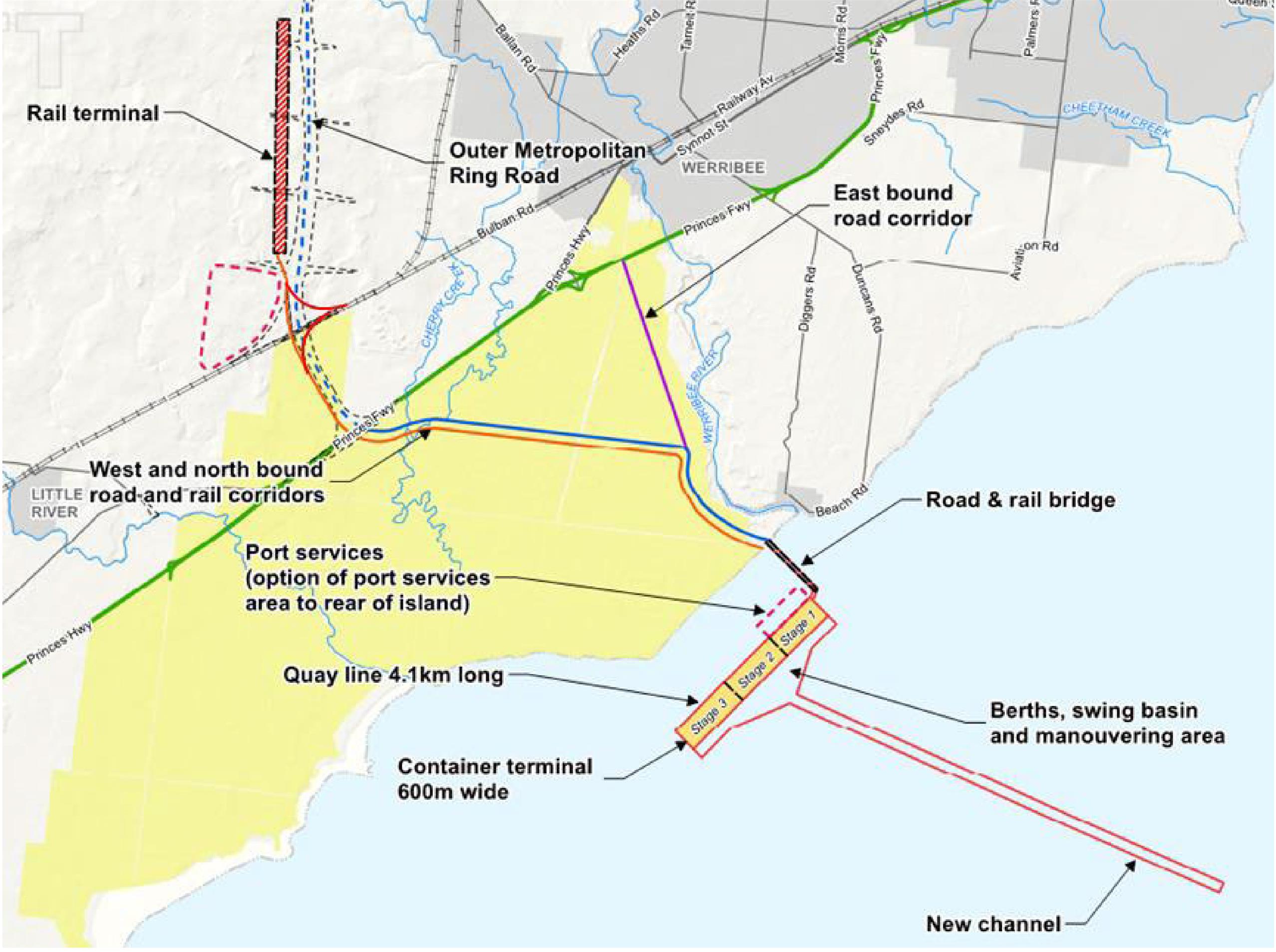
In 2018 Infrastructure Victoria recommended that Victoria’s second container port be located at Bay West Port on the western shores of Port Phillip Bay. The development is proposed to include a land reclamation area of around 4.5 kilometres in length that will be connected to the shore via a multi lane bridge and connect to Victoria’s road and rail freight network. Bay West Port is proposed to be integrated into the region’s future network of logistics facilities including the WIFT (located outside of the Avalon Corridor).
Following Infrastructure Victoria’s recommendations the location of the Bay West Port was confirmed as state policy in the Victorian Freight Plan (2018). Updates to the Victorian Commercial Ports Strategy (expected in 2023) will provide further detail on the scope of the Bay West project and update the proposed timing based on current forecasts.
In recognition of the state government’s commitment to the Bay West Port there is a short term need to undertake detailed design to further define the port site location and supporting land connections. Following this there is a need to protect associated buffers and transport connections through appropriate planning controls.
Landside development of the Bay West Port is planned to include a future rail marshalling facility west of or within the OMR Transport Corridor (to be confirmed). Associated port precinct areas are also to be confirmed through specific studies proposed as part of the updated Victorian Commercial Ports Strategy. The Infrastructure Victoria report considered options for locating port precinct areas within the land reclamation footprint on WTP land or in land areas either side of the existing rail corridor.
The OMR will include a future southbound connection into the Bay West Port to enable road and rail freight movements. Whilst this southbound connection has not yet formally reserved planning for the Bay West Port assumes that future north-south road and rail connections to the OMR will be elevated over the Princes Freeway while east-west road connections will be at grade with the Princes Freeway.
The preferred Bay West Port road network concept includes a westbound and northbound connection at the OMR intersection as well as a separate eastbound interchange located closer to Farm Road or the Werribee Main Road intersection.
A corridor connecting to the Princes Freeway at the Werribee Main Road interchange will reduce eastbound journeys towards Melbourne by around 17 kilometres when compared to an arrangement that only has one connection to the Princes Freeway at the OMR intersection. Figure 10 depicts indicative design of transport connections to Bay West Port (Infrastructure Victoria 2017).
The future freight network within the Avalon Corridor will play a critical role for Victoria into the future by accommodating:
- Growth of extractive industries
- Increased road and rail freight movements
- Increased air freight and passenger movements at Avalon Airport
- New sea freight movements through Bay West Port.
Whilst there may be some synergies for these freight operations it should be noted that the Bay West Port and Avalon Airport have very different freight roles. Port freight is characterised by large volumes and typically includes non-time sensitive goods while air freight is characterised by small volumes and typically includes high value or perishable goods.
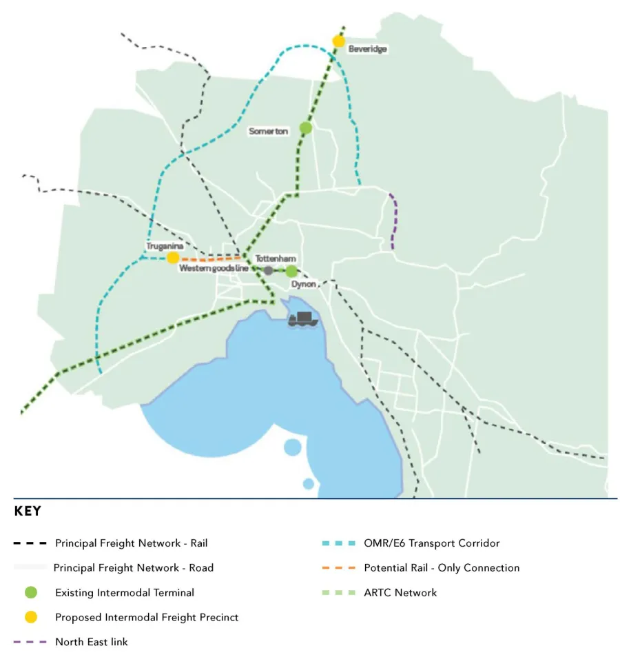
The biggest increase in freight movements is expected to arise from the Bay West Port and designated interstate freight terminals including the WIFT. Figure 11 conceptualises how freight could be expected to move with the establishment of WIFT and the Bay West Port over the next 10+ years.
The development of WIFT is currently being considered as part of a major project business case funded by the Australian and Victorian governments. The facility will enable intra and interstate freight movements with proposed connections to the Inland Rail Service capable of accommodating double-stacked 1 800 metre trains. The site for the WIFT is under consideration along with the Beveridge Interstate Freight Terminal (BIFT).
The existing rail network within the Avalon Corridor can be summarised as follows:
- One standard gauge (SG) track servicing freight (north of BG tracks)
- Two broad gauge (BG) tracks servicing passengers (south of SG track)
- Existing Train stations at Lara and Little River
- Current V/Line passenger connections to and from Geelong via the Regional Rail Link (RRL)
- Historic passenger connection to from Geelong via the Werribee Line (up until 2015) which includes separate SG and BG tracks to Melbourne
- Current freight connections via the Werribee Line.
Future rail infrastructure development can be summarised as follows:
- Freight rail connections to Bay West Port (refer to Section 7.5)
- Rail connections within the OMR Transport Corridor (refer to Section 2.4.2)
- Western Rail Plan including Geelong Fast Rail (refer to Section 2.4.3)
- Suburban Rail Loop (SRL) a 90 kilometre rail line linking major services from the Frankston to Werribee Lines via Melbourne Airport (refer to Section 2.4.3)
- Connection of the RRL to metro services via Werribee Station
- Potential rail line and station to service Avalon Airport
- Potential duplication of the standard gauge ARTC line through the Avalon Corridor.
Existing aviation infrastructure at Avalon Airport can be summarised as follows:
- Provides both passenger and freight transport services.
- Currently houses a 1.5 million litre fuel storage facility which is serviced by regular road tankers out of the Geelong Refinery site.
- Currently has mains connection supplies for gas water and electricity.
- Sewerage is a standalone system incorporating detention ponds on the site without an EPA discharge license.
Future aviation infrastructure can be summarised as follows:
- The Avalon Airport Master Plan (2015) includes direction for infrastructure development over the next 20 years.
- The long-term plan includes two additional runways with one running parallel (north-south) to the east of the existing runway and another potential runway running in an east-west direction to allow for full utilisation of the airport in any weather condition.
- Development of the second parallel runway will likely be 20 years away while the potential development of the third cross runway would be 50 years away (if determined necessary).
- Future provision for a direct fuel connection between the existing VIVA Energy pipeline and the airport. Estimated cost is up to $20 million dollars and is currently not financially viable.
- Planned pipeline to connect to on site fuel storage facility within 10 years with fuel tanks to be relocated to the western boundary.
- Possible future rail link to Avalon Airport via the Geelong-Melbourne rail line has been reserved by a Public Acquisition Overlay (PAO) and is reflected under the current Avalon Airport Master Plan (2015).
- Although a rail reservation to the airport has been designated through a PAO Avalon Airport has indicated their preference for a new airport station to be located on the existing rail line rather than bringing a new rail connection into the airport terminal.
- Avalon Airport has indicated a longer term plan to relocate the main terminal to the same location as their preferred station location (along the existing rail line). However this proposal needs to be considered against the completion of the Geelong high speed rail investigation and objectives to protect the existing green break north of the Princes Freeway.
ACS - Figure 11 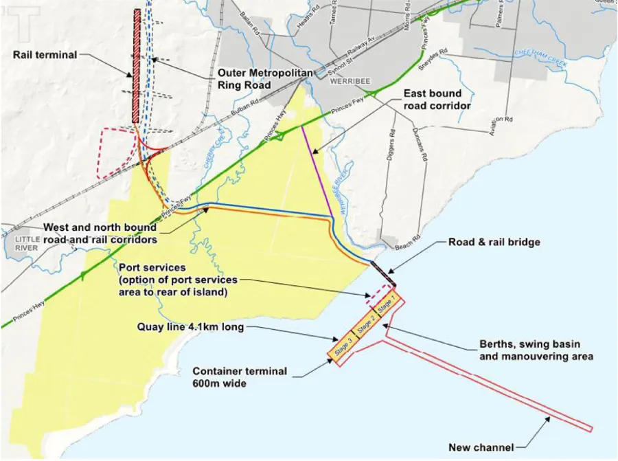
ACS - Figure 10
Click on an image to view details and enlarge
Page last updated: