Policies within Plan Melbourne were a key driver for the development of this Strategy.
ACS - Metropolitan and municipal context
Avalon Airport is recognised in Plan Melbourne 2017-2050 as a state significant Transport Gateway with the purpose to secure adequate gateway capacity for moving passengers and freight into and out of Victoria and support future employment and economic development opportunities at major ports airports and interstate terminals.
Key policies
Policy 4.5.2 Protect and enhance valued attributes of distinctive areas and landscapes seeks to recognise and protect green wedges and peri-urban areas which contain landscapes that have significant geographic and physical features.
Policy 7.2.2 Strengthen transport links on national networks for the movement of commodities seeks to foster economic opportunities associated with the movement of goods within Victoria interstate and internationally. This policy seeks to identify key freight corridors and interstate freight terminals.
Policy 7.2.2 specifically recognises that ‘the Avalon corridor near Geelong contains nationally significant economic assets including airport road rail and waste facilities. This corridor must be safeguarded for state infrastructure opportunities and complementary development in the future as well as maintaining a settlement break between Melbourne and Geelong. Land use buffers for infrastructure and Avalon Airport and areas of high biodiversity value including Ramsar conservation areas must be protected.’
The G21 Regional Growth Plan is a reference document to State Planning Policy Clause 11.01- 1R Geelong G21. The Plan provides a strategic land use and growth framework to manage population growth of the region to 500 000 by 2050. The Plan identifies Avalon Airport and surrounds as an ‘employment growth’ opportunity and the development of a national transport and logistics precinct which includes and connects Avalon Airport the Port of Geelong and the Geelong Ring Road Employment Precinct to maximise efficiencies in freight movement. This includes improving road and rail access to and from existing broad and standard gauge rail networks and major roads including the Princes Freeway and the Geelong Ring Road.
In its metropolitan and municipal context the Avalon Corridor is strategically located between the outer edge of metropolitan Melbourne at Werribee and Victoria’s second largest city of Geelong. The Avalon Corridor spans part of WCC and CoGG with the alignment of Little River forming the municipal boundary line.
The Avalon Corridor contains a significant range of cultural and environmental values as well as important infrastructure and assets. There is limited residential development within the established settlements of Lara and Little River.
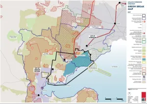
The existence of important environmental and infrastructure assets gives rise to competing objectives. A particular strategic consideration is how these matters can be balanced and appropriately addressed through relevant policy frameworks. Noting this will constitute a functional role of the Frameworks Plan there is a need to first consider the existing context and the range of relevant and influential considerations. This includes matters such as the long held planning principle of maintaining a green break between Melbourne and Geelong (land maintained for farming and agriculture environmental value landscape setting and some low density and rural residential living). For clarity a green break is also referred to in some policy documents as a ‘settlement break’ or ‘non-urban break’).
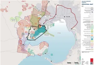
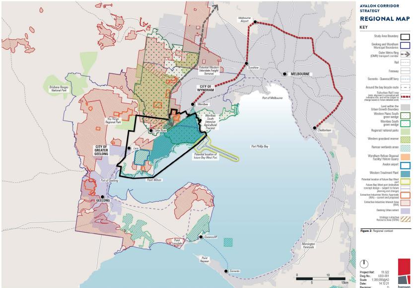
The general metropolitan and municipal context of the Avalon Corridor is illustrated in Figure 2 with further details of environmental and infrastructure assets within the Avalon Corridor outlined under relevant headings.
A range of significant environmental assets are located within the Avalon Corridor, including:
- Port Phillip Bay (Western Shoreline) Ramsar site
- Conservation reserves, such as:
- Port Phillip Bay Coastal Reserve
- Limeburners Bay Flora and Fauna Reserve
- The Spit Wildlife Reserve
- Werribee River Regional Park
- Werribee Plains South and Werribee South green wedges
- Western Grasslands Reserve
- Significant waterbodies, such as:
- Western Treatment Plant (WTP) sewage treatment and conservation ponds
- Werribee-Avalon Area Nationally Important Wetlands (including the former Cheetham Saltworks site)
- Waterways and riparian corridors (including Werribee River, Little River, Lollypop Creek, Cherry Tree Creek and Hovells Creek)
- Swamplands (Ryans Swamp Wetland, Paul and Belfrages Swamp, Edgars Road Swamp and Cherry Swamp)
The above environmental assets are notable for providing for significant wildlife habitat for a number of endangered and critically endangered species and communities, such as the Orange-bellied Parrot and Natural Temperate Grasslands of the Victorian Volcanic Plains.
The regional and metropolitan significance of the Avalon Corridor is reinforced by the number of state and nationally significant infrastructure assets it contains. Major infrastructure assets identified below are further expanded upon in subsequent sections of this Strategy.
Major infrastructure assets within the Avalon Corridor Strategy include:
- Avalon Airport, as Victoria’s second international airport
- Princes Freeway, as the main road transport corridor between Melbourne and Geelong
- Geelong-Melbourne rail line, including the possible Avalon Airport Rail Link
- Melbourne Water WTP
- Wyndham refuse disposal facility (RDF), which serves a metropolitan catchment
- Cherry Creek Youth Justice Facility
- Point Wilson Munitions Facility
- Oil pipelines and high pressure gas pipelines
- The Outer Metropolitan Ring (OMR) Transport Corridor, as a future transport project with alignment confirmed and protected
- Bay West Port, designated by state government as the location for Melbourne’s second container port terminal (targeted for operation from around 2055)
- Areas identified as containing or potentially containing extractive resources needed for the construction industry, such as rock, sand and gravel. These are shown as either Work Authorities (WAs) where quarries are operating or have licence to operate, Extractive Industry Interest Areas (EIIAs) where potential extractive resources of state significance have been identified, or Strategic Extractive Resource Areas (SERAs) where extractive resources of state significance have been confirmed.
The Avalon Corridor provides a physical break in urban development between Melbourne and Geelong, being Victoria’s capital city and second largest city respectively.
History of green break
The concept of containing the extent of Melbourne growth has its basis in Town and Country Planning Act 1944, and has been progressively enshrined in planning policy in the following decades, culminating in the application of the current Metropolitan Melbourne Urban Growth Boundary (UGB).
Whilst there has also been a long held planning principle to maintain a green break between Melbourne and Geelong, this has rarely been explicitly stated with the metropolitan strategic documents prepared for Melbourne over recent decades.
Of interest, Planning Policies for Metropolitan Melbourne 1971 prepared by the former Metropolitan Board of Works (MMBW) adopted a corridor approach for accommodating future population growth, which resulted in the creation of green wedge areas still found within the boundary of metropolitan Melbourne, identified by the Green Wedge Zone (GWZ). This 1971 document also identified the need for a metropolitan-regional boundary and identified land south of the Princes Freeway as an important non-urban area. This included land still known as the Werribee South agricultural precinct.
Melbourne 2030 introduced the concept of the UGB in 2002 and served to formally cement this break between the outer edge of Metropolitan Melbourne at Werribee. Since then, there have been significant expansions to the UGB, including in 2010 and the subsequent logical inclusions process.
Plan Melbourne 2017-2050 outlines the importance of connection between cities and regions under Direction 7.2 Improve connections between cities and regions. This Direction explicitly states that the Avalon Corridor should be preserved for state infrastructure opportunities but also to ensure a maintenance of a settlement break between Melbourne and Geelong.
The Greater Geelong Planning Scheme (Clause 21.06-2) and Wyndham Planning Scheme (Clause 21.02-1) both identify the need to maintain a green break between Geelong and Werribee. For Greater Geelong, the G21 Strategy further contains a principle relating to ‘connected communities’, which refers to the need to provide settlement breaks between towns to maintain their unique identities.
Currently the state government is undertaking program of investigating Distinctive Areas and Landscapes within designated peri-urban areas (through relevant legislation including Part 3AAB of the P&E Act 1987). However no part of the Avalon Corridor has to date been designated as an area for investigation. Despite this, large areas of the study area form part of the Port Phillip Bay (Western Shoreline) and Bellarine Peninsula Ramsar Site, in addition to numerous sites of Aboriginal Cultural Heritage sensitivity and Victorian Heritage Register listings.
Greater Geelong Settlement Strategy
The principle of a settlement break between Melbourne and Geelong is reinforced by the Greater Geelong Settlement Strategy 2020, which was formally incorporated into the Greater Geelong Planning Scheme on 6 May 2021 via amendment c395. The Settlement Strategy clarifies what is defined as the green break or non-urban break, and its location between Geelong and Melbourne (Wyndham), as per the following statement (page 78-79):
Non-urban breaks are critical to the identity of our municipality and individual townships and will also help establish long term settlement boundaries. There are some physical land constraints and uses that, by their nature, help maintain these breaks. However, in other cases, non-urban breaks will need to be more actively managed. Non-urban areas outside the Urban Growth Boundary in Melbourne are known as green wedges and are managed via a Green Wedge Management Plan. This could be an option for managing the non-urban breaks outside long term boundaries in Greater Geelong.
The following areas help maintain a non-urban break between Geelong and Melbourne:
- The Ramsar wetlands (mainly associated with Melbourne Water WTP and areas along the northern shore of Corio Bay and Outer Harbour)
- Areas reserved for conservation purposes, including the You Yangs Regional Park, part of the Brisbane Ranges National Park, the Serendip Sanctuary and the Mount Rothwell Conservation and Research Centre
- Areas with landscape value, such as the Barrabool Hills and You Yangs
- Areas containing infrastructure of regional and state significance, such as WTP and Avalon Airport.
The Settlement Strategy contains further principles and directions relating to the settlement boundary. Principles and directions relevant to the green break between Geelong and Melbourne (Wyndham) include:
- Principle
Maintain the unique identity of Greater Geelong and its townships. - Directions
- Maintain the non-urban breaks between Geelong and Melbourne (Wyndham), Geelong and the Surf Coast, urban Geelong and the Bellarine Peninsula, and the townships on the Bellarine Peninsula.
- Assess areas with special local environmental or landscape values and consider options to help preserve and manage these breaks into the future.
DELWP green wedge strategic work
Melbourne’s green wedges are also vital for protecting green break land on the metropolitan fringe, with the concepts around the need to protect these dating back to the 1860s. Protection of Melbourne’s green wedges is included in the Planning and Environment Act 1987 as well as throughout the Victoria Planning Provisions.
Of relevance, DELWP is undertaking detailed strategic work to strengthen the green break role of nominated GWZ areas, which includes part of the Avalon Corridor within WCC. This project is part of the Victorian Government’s commitment to protecting Melbourne’s green wedge and peri-urban areas as outlined in Actions 17, 72 and 73 of Plan Melbourne. The project considers agricultural land within 100km from Melbourne and therefore has implications for both CoGG and WCC.
In 2020, DELWP released the Planning for Melbourne’s Green Wedges and Agricultural Land Consultation Paper for public consultation. Page 20 of the Consultation Paper notes that ‘the western study area is an important non-urban break between Melbourne and Geelong’. As such, the current designated GWZ land and the additional strategic work being undertaken to strengthen controls for its planning and protection will function to further reinforce a green break within and beyond the Avalon Corridor.
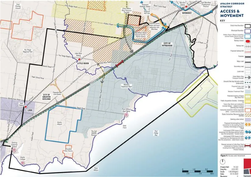
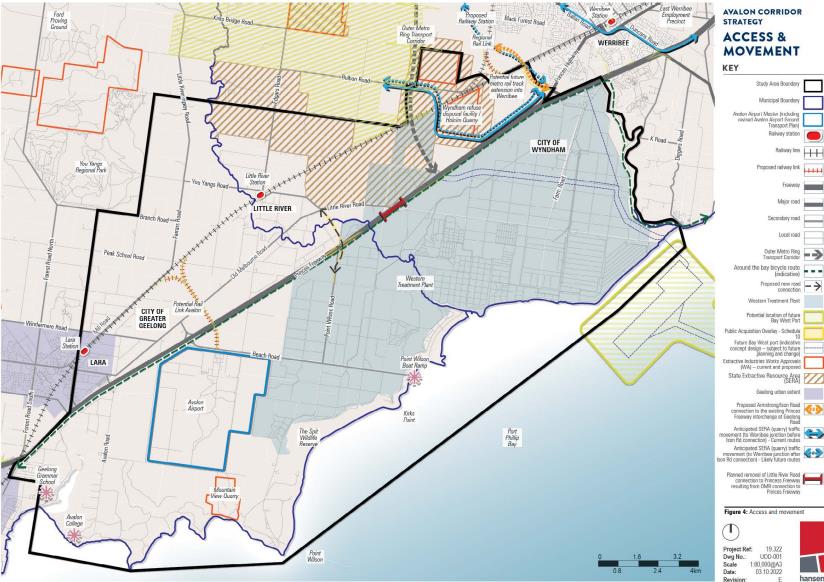
The key access and movement networks within the Avalon Corridor are illustrated on Figure 4.
Avalon Airport
Avalon Airport accommodates domestic and international flights, thereby playing a supporting role to functions and operations of Tullamarine Airport. Operational capacity of the airport has room for expansion, in line with the federally endorsed Avalon Airport Master Plan (2015). Expansion of airport activities will elevate Avalon Airport’s status as Melbourne’s second international airport.
Princes Freeway and Omr Transport Corridor
Princes Freeway is the major piece of road infrastructure which bisects the Avalon Corridor, consisting of a separated carriageway with three lanes of traffic in each direction.
Princes Freeway plays a significant role on the movement of freight and people between Melbourne, Geelong and the regions beyond. Ensuring quick and reliable travel times between Melbourne and Geelong on the Princes Freeway is an important strategic priority to be maintained into the future.
The functional role and operation of the Princes Freeway will be further augmented with the construction of the multi-modal OMR Transport Corridor, estimated to be built within 15-30 years.
Geelong-Melbourne rail line
Like the Princes Freeway, the Geelong-Melbourne rail-line plays a significant role in the movement of people between Melbourne, Geelong and the regions beyond. The potential for a future rail link to Avalon Airport has been protected through a Public Acquisition Overlay (PAO). The existing rail-line configuration consists of three running lines: the eastern two being broad gauge (BG) intrastate lines servicing mainly passenger trains to Geelong; and the third western line being a standard gauge (SG) single bi-directional intrastate line.
The Western Rail Plan is a major Commonwealth and Victorian Government initiative that sets out objectives to deliver a faster, high-capacity rail network servicing growing outer suburbs and regional cities. The Plan seeks to deliver full separation of regional and metro services on the Geelong and Ballarat lines. The Geelong Fast Rail project is a targeted aspect of the Western Rail Plan and seeks to deliver faster journeys between Geelong and Melbourne, with a travel time of around 50 minutes. Construction is anticipated to commence in 2023.
Another associated rail project is the Suburban Rail Loop (SRL), a 90 kilometre rail line that willlink every major service from the Frankston Line to the Werribee Line via Melbourne Airport. SRL West from Melbourne Airport to Werribee will build on the major road and rail projects already being delivered in the west, including Geelong Fast Rail.
Interstate freight terminals
The Victorian Government Freight Strategy (2018-2050) designates the Western Interstate Freight Terminal (WIFT) and the Beveridge Interstate Freight Terminal (BIFT) as the future intermodal freight terminals for Melbourne and Victoria. At a metropolitan scale the proposed WIFT at Truganina (north of the Avalon Corridor) is a major infrastructure initiative of state importance in the longer term. The Victorian Government is currently finalising the full business case for the WIFT and BIFT, including the preferred transport connections and staging. The business case is jointly funded by the Victorian and Commonwealth Government. The location of the WIFT is shown on Figure 2.
The Department of Transport’s fact sheet on Victoria’s new intermodal freight precincts notes that:
the Victorian Government is planning to deliver new intermodal freight precincts at Truganina in Melbourne’s west and Beveridge in Melbourne’s outer north. The role of the new precincts will be primarily to handle interstate freight, but also the import and export container trade.
Currently, interstate freight containers are railed to terminals at Dynon adjacent to the Port of Melbourne, and then trucked to the outer suburbs and regional areas. However, the Dynon terminals have limited space and capacity, and can be difficult to access due to increasing congestion on the inner Melbourne road and rail networks.
The intended benefits of the WIFT is to allow more efficient freight movement by providing modern terminal facilities closer to the large industrial cluster in Melbourne’s west, which in turn will reduce the time and length of truck trips. This will have the added benefit of reducing freight traffic through the inner west, potentially removing up to 2,000 truck movements daily. It is also intended for the WIFT to include provision for connection to the Bay West Port. Other benefits of the WIFT as a long term strategic option have been highlighted to:
- Significantly improve the capacity of interstate freight transport in the north-south and east-west national corridors connecting Melbourne;
- Complement other improvements to the north-south intermodal rail supply chain with matching capacity and service level improvements;
- Enhance national productivity by lowering the door-to-door cost of freight for interstate movements;
- Create opportunities for urban renewal in the North Dynon area;
- Reduce truck movements through Melbourne’s inner west; and
- Improve rail access for port-related freight by removing many non-port freight movements from the Dynon precinct.
The West Growth Corridor Plan (2020) locates the WIFT on the northern side of Boundary Road, Truganina, between Christie’s Road and the OMR Transport Corridor (well outside the Avalon Corridor study area).
Once state government determines its preferred solution, necessary steps will be taken to reserve land and access corridors required for future interstate terminals through relevant planning scheme provisions.
With regard to timing, 0-5 years has been indicated for planning and prioritisation of further investigation, and then between 10-30 years for the anticipated completion.
The Avalon Corridor is also located adjacent to a number of important environmental, open space, extractive resource and tourism related assets, including:
- Port Phillip Bay and Corio Bay coastal environs (to the south).
- The Western Grasslands Reserve (to the north), which will become Victoria’s largest native grasslands reserve and a site of strategic importance as an offset for Melbourne’s continued urban expansion within the UGB. The reserve plays a strategic role in firming up Metropolitan Melbourne’s UGB and supporting the protection of the green break between Wyndham and Greater Geelong. A small part of the reserve is located within the Avalon Corridor.
- The You Yangs Regional Park (to the west), which constitutes the single most significant landscape feature within the wider region. Strategic land use directions for the You Yangs Regional Park are guided by the You Yangs Precinct Master Plan (2021).
- The Werribee Open Plains Zoo and Werribee Mansion (to the east), which is a regionally important tourism node. The state government recently announced $84 million funding to make Werribee Open Plains Zoo the most significant open range zoo in Australia, to transform it into a world class facility, including a 1.6km tree top Sky Safari gondola boasting 360-degree views.
- Strategic Extractive Resource Areas (SERAs) in WCC, which contain strategic extractive resources (hard rock) needed for the construction industry and major state infrastructure projects. To protect these resources, the Victorian Government introduced the State Resource Overlay (SRO) in 2021.
The Avalon Corridor is also broadly influenced by the location of the other major land uses outside of, but within close proximity, including:
- Geelong Ring Road Employment Precinct
- Port of Geelong
- Pivot City Innovation Precinct
- Northern Geelong Growth Area
Ongoing investigations into the East Werribee Employment Precinct (EWEP), located just outside of the Avalon Corridor to the east are being undertaken. EWEP is proposed to be developed as a mixed use business precinct generating over 50,000 new jobs. It will be centred on a new lake and capitalise on the current heritage and economic base of the former Werribee Technology Precinct and emerging Health, Education and Justice Precincts. The proposed development will help to establish Werribee as a key business, service and employment hub of Melbourne’s west.
ACS - Figure 4 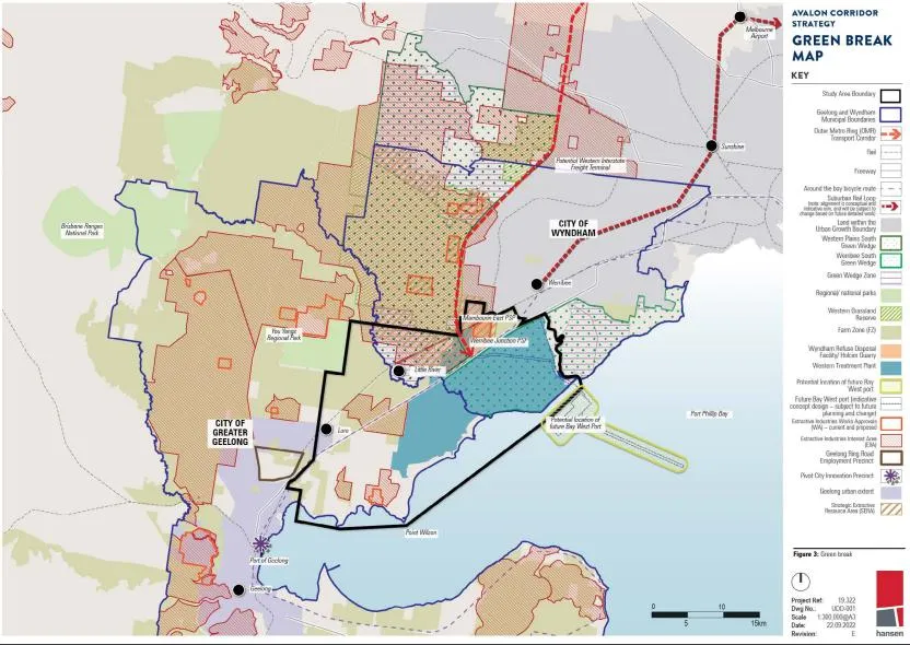
ACS - Figure 3 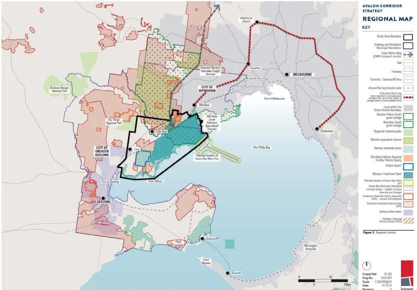
ACS - Figure 2
Click on an image to view details and enlarge
Page last updated: