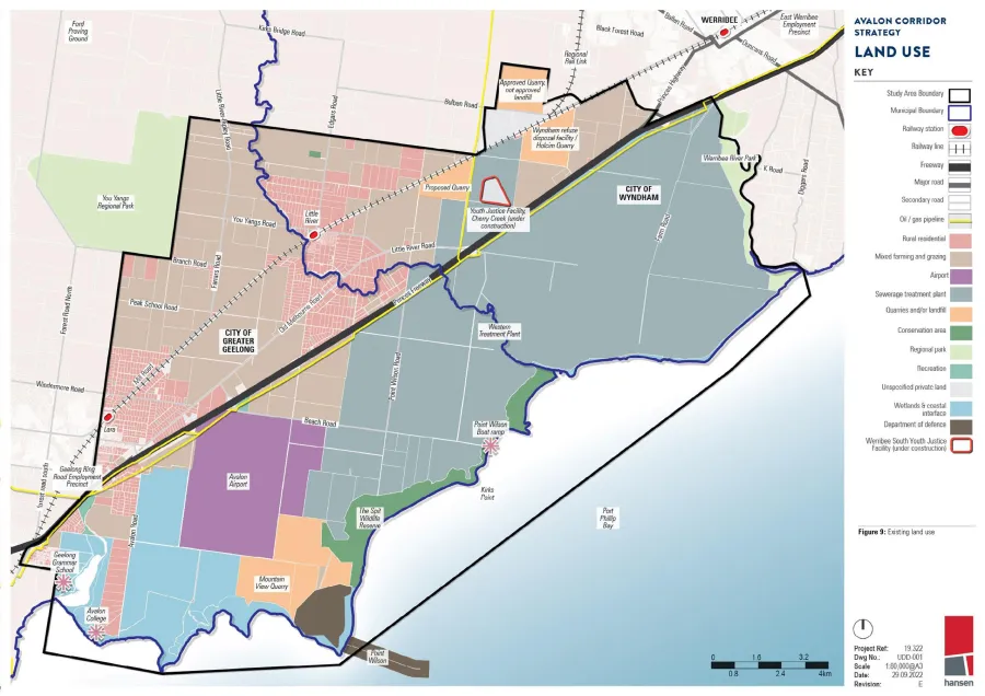
Established land uses within the Avalon Corridor are outlined below and illustrated on Figure 10.
ACS - Land use analysis
The major land uses within the Avalon Corridor include:
- Princes Freeway
- Melbourne-Geelong rail line
- Western Treatment Plant (WTP)
- Avalon Airport
- Point Wilson Munitions Facility
- Extractive industries and quarries (various locations)
- Wyndham RDF
- Agriculture
- Township of Little River
- Township of Lara
- Education facilities including Geelong Grammar and Avalon College
- Cherry Creek Youth Justice Facility
- Crown land and coastal conservation reserves
- Aquaculture (onshore and offshore) including Bates Point Aquaculture Fisheries Reserve
These major land uses are described briefly below:
- The Princes Freeway transport corridor constitutes a dual divided road carriageway with 3 lanes in each direction. Due to carriageway width and treatment the Princes Freeway effectively bisects the Avalon Corridor into a northern and southern precinct.
- The Melbourne-Geelong rail transport corridor consists of three running lines with the eastern two being broad gauge (BG) intrastate lines servicing mainly passenger trains to Geelong and the third western line being a standard gauge (SG) single bi-directional intrastate line. Two train stops are located with the Avalon Corridor at the townships of Lara and Little River. Although the rail alignment creates a physical barrier through the landscape it is not a substantial as the divide created by the Princes Freeway.
- The largest single land use and land holding within the Avalon Corridor is the WTP comprising approximately 10 500 hectares. The WTP provides an essential service treating over half of Melbourne’s sewage. Land uses and activities across the site include treatment lagoons resource recovery (recycled water biosolids and biogas) agriculture biodiversity conversation wetland and grassland ecosystems heritage conservation education and tourism (recreational birdwatching). Other relevant considerations include:
- Approximately 5 000 hectares of the site is competitively outsourced for broad acre agriculture which is a compatible land use within the sewage treatment odour buffer and makes use of recycled water produced on site. Agriculture is also compatible with the biodiversity conservation function of WTP and overall land management needs.
- In addition to low-cost sewage treatment the site is a Ramsar-listed wetlands of international significance forming a major segment of the Port Phillip Bay (Western Shoreline) and Bellarine Peninsula Ramsar site. Over 300 bird species have been recorded on site and the lagoons and foreshore supports over 120 000 waterbirds including internationally significant migratory birds. Melbourne Water is obligated to protect these values under the Environment Protection and Biodiversity Conservation Act (EPBC Act) 1999.
- Biodiversity offset credit sites have been established under DELWP’s program on WTP land parcels north of the Princes Freeway. Additional sites are being explored including south of the freeway. These require on-going protection under the biodiversity offset credit program limiting potential future land use changes.
- A further concentration of land use and activity is associated with Avalon Airport which comprises approximately 1 750 hectares. Although all current operations of the airport are concentrated towards the northern end of the site and all flights are currently accommodated on the existing north-south runway the Avalon Airport Master Plan (2015) outlines future development and land use across the landholding. The Master Plan accommodates a second north-south aligned runway and third east-west aligned runway. Land use and development within the Avalon Corridor must not impact on the ability to develop these additional runways.
- The Department of Defence (DoD) Point Wilson Munitions Facility is a 326 hectare site located to the south of Avalon Airport which has been operating since 1961 and is the only government owned importation facility capable of large scale movement of explosive ordinances. It is the primary importation and storage point for munitions in Australia including capability for road and sea transportation. Recognising the importance of this asset DoD has commenced remediation of the existing waterside infrastructure in order to recommence large scale importation. Due to the use of the site for munitions storage and distribution ‘safety arc’ separation distances are a relevant consideration to the Avalon Corridor Strategy.
- A number of existing and proposed quarries are located within the Avalon Corridor. Currently operational quarries include the Holcim Quarry (to the northeast) and the Mountain View Quarry (south of Avalon Airport). A further two approved quarries are located to the north and west of the Holcim Quarry. EIIAs across the Avalon Corridor indicate the likely presence of additional extractive resources to be protected for possible future extraction.
- The Wyndham RDF is located adjacent to the Holcim Quarry and functions as a solid waste landfill. The RDF effectively fills in previously excavated quarry areas and has EPA approval to ‘mound’ buried refuse above ground level to a height of approximately 24 metres.
- Open rural landscapes located north of the Princes Freeway are located within the FZ or GWZ. Landholdings in this area have become fragmented over time and are generally not of adequate scale to accommodate broad acre farming. Smaller scale cropping and livestock grazing is undertaken on various land parcels.
- The township of Little River is located within the Avalon Corridor to the north of the Princes Freeway. While Little River straddles the municipal boundary between WCC and CoGG the township core is located to the east of the alignment of the Little River waterway (within Wyndham). Urban zoned land (Township Zone and Low Density Residential Zone) within Little River covers approximately 40 hectares. Surrounding this township core the wider extent of Little River consists of dwellings on larger rural allotments within the FZ or GWZ.
- The eastern extent of the Lara township extends into the Avalon Corridor along its western edge with land use being predominantly residential within the Rural Living Zone (RLZ). The urban zoned land of Lara (predominantly General Residential Zone) within the Avalon Corridor covers in the order of 890 hectares.
- Apart from two small clusters of dwellings to the west and south of Avalon Road there are no other dwellings or residential settlements located to the south of the Princes Freeway.
- Part of the Geelong Grammar campus is located within the south western corner of the Avalon Corridor. Geelong Grammar also owns the Avalon College campus located on Avalon Road.
- Cherry Creek Youth Justice Facility is a newly constructed youth justice facility located southwest of the Wyndham RDF between the Princes Freeway and Melbourne-Geelong rail line.
- Werribee River Regional Park is located along the eastern boundary. Parks Victoria has plans for a redevelopment of the park which will improve accessibility down to the bay from the Princes Freeway.
The following observations are made regarding patterns of land size and ownership within the Avalon Corridor:
- The WTP constitutes the single largest land holding within the Avalon Corridor comprising approximately 10 500 hectares of state government owned and controlled land.
- Other larger land holdings within the Avalon Corridor include Avalon Airport the former Cheetham Saltworks site Mountain View Quarry Point Wilson Munitions Facility Wyndham RDF and Holcim Quarry the coastal foreshore reserve (Crown land) and Cherry Creek Youth Justice Facility.
- The smallest land holdings generally constitute residential properties within the township centres of Lara and Little River along with rural residential lots surrounding these settlements.
- The balance of land within the Avalon Corridor is broadly characterised by moderate to large rural properties which are relatively free of development and exhibit an open rural landscape character.
Amendment VC175 (gazetted May 2020) updated the Planning Policy Framework and Clause 53.10 - Uses with Adverse Amenity Potential to improve how the planning system addresses buffers for amenity human health and safety impacts. Major current and proposed land uses in the Avalon Corridor that require buffer separation and amenity management include:
- Western Treatment Plant (WTP)
- Bay West Port
- Avalon Airport (see Section 5)
- Point Wilson Munitions Facility
- Quarries including designated SERAs
- Wyndham RDF
Buffer considerations for these land uses are outlined below:
- There is potential for odour impacts associated with the WTP. Odour risk during routine operation is generally low due to the large scale of the site and associated buffer distances between treatment plant odour sources and the site boundary. Odour risk increases in association with periodic maintenance activities which can result in complaints. Increasing development encroachment will increase the odour risk profile of the WTP.
- Avalon Airport has the potential to create amenity impacts through aircraft noise. Aircraft noise is likely to increase in the future as airport operations are expanded to accommodates the possible second and third runways. This issue is separately addressed in Section 5.
- Safety arc separation distances are relevant to the Point Wilson Munitions Facility. These distance requirements vary depending on the type of munitions being stored at the site. Department of Defence have advised that a safety arc of 1.5 to 2 kilometres from the external boundaries of the site should be maintained.
- Buffer separation and amenity impacts from the Wyndham RDF and various quarries in the Avalon Corridor are similar as both are subject to EPA guidelines and requirements. In 2015 WCC commissioned GHD to prepare the Wyndham Vale Buffer Study: Environmental Audit Report to assess potential environmental risks. The report also outlines appropriate buffer distances for sensitive land uses and considers potential land uses that may be located within the buffer distance.
- Landfills have the potential to impact the surrounding environment and community by discharging landfill gas for more than 30 years after closure. Any building or structure is considered a sensitive use due to the risk of explosion or asphyxiation. Consequently land use change or development near landfills require specific consideration.
- Potential odour impact arising from landfill operations is also an important consideration for setting buffer distances. Specific modelling further determined that the area of medium to high risk of odour may extend beyond the default EPA 500 metre buffer distance. However a default 500m buffer for landfills that accept putrescible waste (also known as Type 2 landfills) should be applied in accordance with EPA Publication 788.3 Best Practice Environmental Management: Siting design operation and rehabilitation of landfills (2015).
- In an operational capacity basalt quarries tend to utilise blasting to prepare rock for excavation. Buffers of 500 metres may be required in some situations.
- As part of the SERA project the Victorian Government introduced a State Resource Overlay (SRO). SRO2 extends around existing quarries in certain circumstances to discourage encroachment of incompatible uses.
- The future Bay West Port is likely to require buffers for noise and light. This should be further investigated by state government with a focus on potential impacts to migratory birds at WTP. WTP forms part of the Port Phillip Bay (Western Shoreline) and Bellarine Peninsula Ramsar site. Buffers will be needed to protect treatment lagoons and other critical habitats from potential noise light and pollution associated with the proposed port infrastructure. Project design should minimise requirements for buffers on WTP land.
- It is also important that the ‘agent of change’ principle is considered as part of any new land use or development within the Avalon Corridor. Under this principle the person or organisation who seeks to change the existing environment has a responsibility for mitigating any offsite impacts.
ACS - Figure 9 
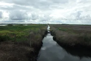
ACS - Water channels within the WTP 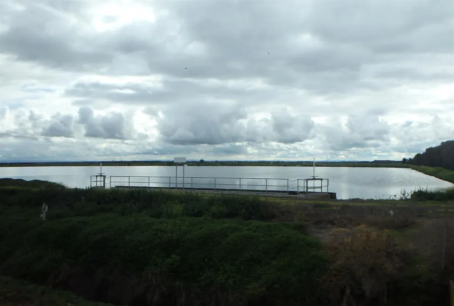
ACS - Lagoons within the WTP


Click on an image to view details and enlarge
Page last updated: