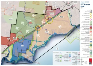
The Framework Plan (Figure 19) guides future detailed land use and development in the Avalon Corridor out to 2050.
ACS - Framework Plan
The Framework Plan is guided by a series of overarching objectives and strategies. More specific objectives and strategies also apply to the North and South Precincts and associated sub- precincts.
Objectives
- To identify and protect land within the Avalon Corridor that constitutes the green break between Geelong and Melbourne.
- To acknowledge and protect land within the Avalon Corridor which has known cultural environmental and landscape character values.
- To identify various state significant assets and promote a coordinated approach to infrastructure planning and development.
- To identify developable land for future employment uses.
Strategies
- Maintain and reinforce green break between Geelong and metropolitan Melbourne and discourage further population growth within existing settlements beyond that outlined in current strategies.
- Protect ongoing and future expanded operations of Avalon Airport.
- Centralise future commercial and industrial development on land located south of the Princes Freeway at Avalon Airport (in line with the Master Plan) and immediate surrounds.
- Enable the future preparation of a Structure Plan for the GAEP.
- Encourage strategic land uses with a focus on employment generating activities.
- Prioritise protection of views to the culturally significant Wurdi Youang north of Princes Freeway.
- Acknowledge the location of the future Bay West Port.
- Protect and enhance the existing and future transport network.
- Minimise and eliminate (where possible) impacts of future land use and development on environmental values and sensitive ecosystems including the Ramsar wetlands.
- Ensure impacts of climate change including sea level rise are considered and appropriately mitigated as part of all future land use and development.
- Protect green wedge and rural landscapes.
- Protect agricultural areas and the right to farm from incompatible land uses and further urban encroachment.
- Protect areas of acknowledged environmental importance including grasslands coastline and Ramsar wetlands.
- Protect non-urban land areas within the Avalon Corridor which are recognised for their cultural and landscape values.
- Protect ongoing operations of the WTP.
- Protect identified SERAs and EIIAs for potential future quarrying activities to meet demand for stone and sand for construction in the metropolitan Melbourne and Geelong areas.
- Position the Avalon Corridor as a tourism gateway and support tourism opportunities associated with existing activities and assets within the region.
- Ensure the protection of existing environmental linkages and wildlife corridors and encourage the provision of new environmental linkages both within the study area and to areas adjacent and beyond the study area.
- Undertake future detailed biodiversity assessments as part of future Structure Plan processes.
South Precinct
Objectives
- To support and facilitate the major expansion of Avalon Airport and the opportunity for commercial and industrial development which benefits from the transport gateway anchored by the airport.
Strategies
- Acknowledge future expansion of Avalon Airport consistent with the Avalon Airport Master Plan (or future updates) including potential for substantial increase in airport traffic and possibility of two additional runways.
- Ensure Avalon Airport remains the critical focus of commercial and industrial development south of Princes Freeway.
- Acknowledge opportunities for airport and related commercial and industrial development of land surrounding Avalon Airport but apply the following guiding principles to future development on and surrounding Avalon Airport: – Airport land – development to be consistent with Avalon Airport Master Plan. – Land surrounding Airport – ensure development of land immediately surrounding the airport includes commercial or industrial activities which are compatible with the airport and benefit the transport gateway locational attributes of the precinct. – Non-airport related – discourage activities which are incompatible with the functional operation of the airport.
- Prepare a Structure Plan for the Greater Avalon Employment Precinct (GAEP).
- Acknowledge the need to undertake additional investigations regarding the current values of the Werribee-Avalon Area Nationally Important Wetland located to the west and south of Avalon Airport including the former Cheetham Saltworks site. Such investigations should be undertaken as part of the Structure Plan process for the GAEP.
- Investigate the potential for an environmental buffer interface between the GAEP and adjacent coastal environs.
- Consider the direct and indirect impacts of the potential development of Avalon Airport and surrounding land on Ramsar wetland sites and consider opportunities to restore the wetlands either as part of development proposal or if development does not proceed.
- Consider visual amenity buffers for existing rural residential areas such as setbacks and landscape buffers along Avalon Road.
- Acknowledge ongoing activities and operations of the Point Wilson Munitions Facility.
- Acknowledge ongoing activities and operations of Mountain View Quarry and have regard for future rehabilitation opportunities.
- Identify opportunities for artistic gateway treatments along Princes Freeway at Avalon Airport and the potential future Avalon Airport Rail Link.
- Acknowledge land identified as EIIAs and land with authorised quarries.
- Undertaken a Safety Management Study (SMS) in accordance with AS 2885 for proposed land use change and development within applicable measurement lengths from gas and oil pipeline easements.
- Consult the Site Planning and Landscape National Guidelines (APA 2020) for guidance on tree species selection within proximity of the gas pipeline easement.
Objectives
- To ensure the long term operation of the WTP and its role relating to resource recovery.
- To support opportunities for sustainable and beneficial recycled water use.
- To encourage renewable energy generation opportunities.
- To ensure the Bay West Port infrastructure and operations do not compromise current or future sewage treatment capacity or operations within the WTP site.
Strategies
- Protect ongoing operations of the WTP.
- Encourage a range of land uses and activities on the WTP site which broadly relate to waste water treatment and resource recovery.
- Protect identified post contact and cultural heritage values and undertake further assessment of Wadawurrung cultural values present at WTP.
- Develop community water literacy and environmental awareness through site based education and visitation programs.
- Investigate the potential use of recycled water for agriculture within the Avalon Corridor.
- Encourage expanded opportunities for alternative forms of energy generation on WTP site including biogas and solar.
- Further develop agricultural production within the WTP site.
- Protect the role of WTP as a functioning part of the Ramsar wetland site and a significant habitat for a number of migratory and shorebird species.
Objectives
- To recognise the future Bay West Port as the location of Melbourne’s second container port terminal as supported by state policy.
- To ensure the Bay West Port infrastructure and operations do not compromise current or future sewage treatment capacity or operations within the WTP.
- To ensure the Bay West Port infrastructure planning and design considers and protects current and future infrastructure and operational requirements of the WTP.
- To minimise and eliminate impacts from the development and operations of the Bay West Port on significant biodiversity and environmental values including sensitive coastal ecosystems and wetlands of international significance.
Strategies
- Implement necessary planning controls to protect long term development opportunities associated with the Bay West Port.
- Undertake baseline environmental and Aboriginal Cultural Heritage Impact Assessments for the final location of the Bay West Port.
Objectives
- To create a substantially landscaped vegetation corridor along the south side of the Princes Freeway.
- To further investigate and develop an off-road bicycle route or shared path to connect the missing link of the Port Phillip Bay Trail between Werribee and Geelong.
Strategies
- Encourage landscaped vegetation buffer along full extent of Princes Freeway ensuring the selection of suitable species which will not impact negatively on gas or oil pipeline easements.
- Encourage development of an off-road bicycle or shared path to connect to the broader regional bike path network including the Port Phillip Bay Trail and trails to the northern areas of Little River Lara and the You Yangs.
Objectives
- To acknowledge existing settlements in Avalon and protect their visual amenity and character through appropriate design controls for development of the GAEP and Avalon Airport.
Strategies
- Acknowledge existing rural residential dwellings and land uses to the west of Avalon Road but discourage further residential development.
- Protect visual amenity through suitable design strategies such as setbacks and landscape buffers to the east side of Avalon Road (within the GAEP boundary).
Objectives
- To protect the coastal environment including areas of acknowledged environmental importance such as the Ramsar wetlands.
- To enhance public knowledge and appreciation of significant coastal environ areas.
Strategies
- Protect areas of environmental importance through existing relevant policy frameworks.
- Encourage targeted and controlled public access links to Port Phillip Bay along the coastline where appropriate.
- Investigate and address impacts of sea level rise and coastal erosion on coastal environs and habitat.
- Encourage regeneration and rehabilitation of wetlands areas including saltmarsh within the areas of the former Cheetham Saltworks site (both public and private land). • Investigate opportunities to expand areas of protected wetlands where appropriate.
North Precinct
Objectives
- To acknowledge the existing settlement area of Lara and facilitate residential development in line with the Lara Structure Plan (2012) and Greater Geelong Settlement Strategy.
- To investigate a township plan and permanent settlement boundary for Little River which protects the current character of Little River and discourages further residential expansion.
- To protect future operations of Avalon Airport from residential encroachment.
- To recognise that the neighbouring townships of Lara and Little River have differences in scale aspirations and resources.
Strategies
- Implement residential land use planning in line with the relevant policies and strategies of the Wyndham and Greater Geelong Planning Scheme.
- Investigate a permanent settlement boundary for Little River and implement appropriate planning controls which discourage further residential expansion.
- Implement appropriate planning controls for Avalon Airport to limit noise impacts on surrounding areas.
Objectives
- To protect open rural landscapes and viewsheds towards the You Yangs.
- To protect identified green wedge and peri-urban land for agricultural and rural land uses.
- To support landowners to undertake rural landscape restoration.
- To acknowledge land identified as EIIAs or SERAs.
Strategies
- Encourage broad scale rural and agricultural activity.
- Discourage the further fragmentation of land.
- Discourage small scale incremental development which would be in conflict with broader land designations.
- Discourage large scale buildings which would interrupt views to the You Yangs including greenhouses.
- Implement appropriate planning controls to protect areas of acknowledged cultural or landscape significance such as the foothills to Wurdi Youang (the You Yangs).
Objectives
- To protect the potential opportunity for the Avalon Airport rail link.
- To enhance the visual amenity of connections into Avalon Airport as the entrance gateway to the Greater Geelong region and Melbourne Western Metro region.
Strategies
- Discourage development which would visually detract from the future Avalon Airport gateway entrance.
Objectives
- To acknowledge the future alignment of the OMR Transport Corridor and its connection with the Princes Freeway.
- To identify opportunities for artistic gateway treatments at the future intersection of the OMR Transport Corridor with the Princes Freeway.
- To support and protect ongoing future operations of the Wyndham RDF and Holcim Quarry.
Strategies
- Encourage an artistic gateway as part of the future OMR Transport Corridor as a new visual marker for the entrance to Werribee.
- Maintain and enforce appropriate buffers associated with the Wyndham RDF and Holcim Quarry.
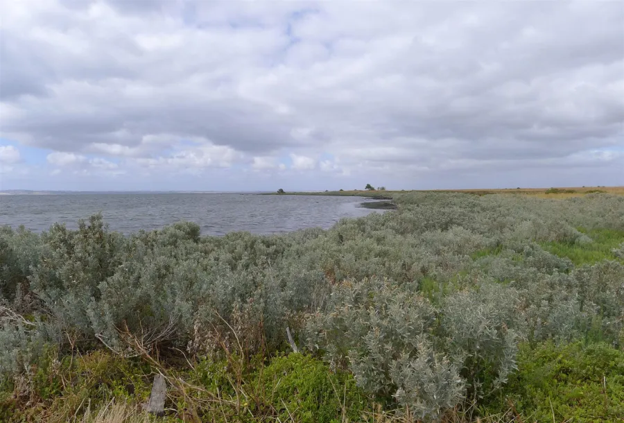
ACS - Port Phillip Bay coastal foreshore within the WTP site 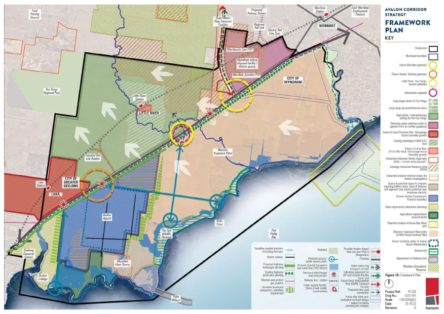
ACS - Figure 19 - Framework Plan 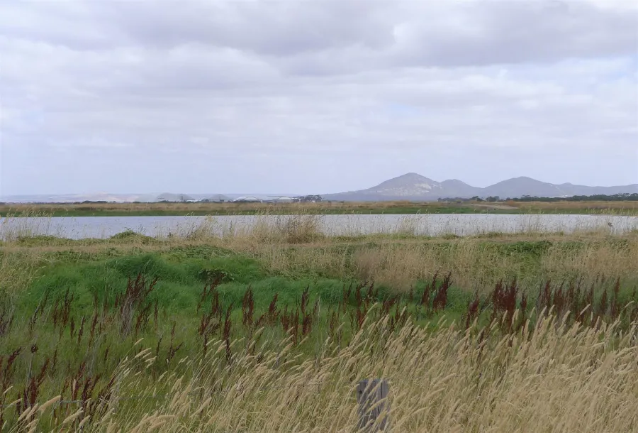
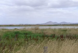
ACS - Views towards Avalon Airport from the WTP, with longer range open views to Wurdi Youang

Click on an image to view details and enlarge
Page last updated: