This section summarises recommendations and spatial considerations relevant to development of the Framework Plan.
ACS - Toward a conceptual framework plan
Major land uses and influences in the Avalon Corridor of relevance to the Framework Plan are spatially illustrated on Figure 17. These include:
- The extent of land area influenced by the future expansion of the Avalon Airport to full capacity including associated noise contours and building height restrictions.
- The extent of buffers and separation distances associated with various land uses such as quarries landfills and the Point Wilson Munitions Facility.
- The location of the future Bay West Port at WTP and its landside connections to the Princes Freeway and the OMR Transport Corridor.
- The extent of designated Green Wedge Zone land within WCC
- The small area of the Western Grasslands Reserve within WCC.
- The extent of the WTP site.
- The location of the Youth Justice Facility at Cherry Creek.
- The location and alignment of the potential Avalon Airport rail link and the OMR Transport Corridor as designated by relevant PAOs.
- Land located inside the UGB that is identified to be included within future PSPs.
- The landscape character values and visual significance of Wurdi Youang (the You Yangs) and foreground landscapes including the foothills.
- Existing quarries and extractive resources as identified by WAs EIIAs and SERAs.
- The extent of important flora and fauna habitat along the coastal foreshore including the Ramsar site.
- Significant flora fauna and ecological communities extending beyond the coastal foreshore.
The key driver of the Avalon Corridor Strategy is to maintain the green break between Melbourne and Geelong and to protect important infrastructure and significant cultural and environmental values.
The Framework Plan seeks to spatially identify high level future land uses within the Avalon Corridor and to clearly designate areas that are suitable for development. The Framework Plan does not attempt to identify all possible land uses within the area. Greater spatial detail on future land use will be provided through subsequent planning processes such as the development of Structure Plans.
The Framework Plan must address the overarching project aims by spatially identifying:
- Land to be protected for its environmental cultural and landscape values.
- Land with capacity to be developed for infrastructure and other complementary employment generating uses.
- Issues and opportunities such as land capability and national and state infrastructure planning.
- Measures required to maintain a green break between Melbourne and Geelong.
In order to inform the opportunities and directions of the Framework Plan it is important to understand synergies and locational attributes associated with different modes of transport including road rail air and sea.
Engagement with Infrastructure Victoria highlighted there are no direct synergies between port and airport activities due to the types of freight preferred by each mode:
- Sea freight typically handles large bulky items (generally of low value)
- Air freight typically handles small lightweight items (generally of high value)
This understanding of the role of different freight modes suggests that there is no justification for the future Bay West Port to be collocated near or connected to Avalon Airport. However there are direct synergies to be drawn between sea and rail freight as both typically carry larger bulky items over long distances.
The Framework Plan is influenced by the timing of various parallel land use and infrastructure development projects within the Avalon Corridor including:
- Further expansion of international flights at Avalon Airport.
- Construction of the second parallel runway.
- The long term status of the third cross runway and whether it is likely to be ultimately required and constructed.
- Construction of improved public transport connections to Avalon Airport.
- Uptake of developable employment land within and surrounding the Avalon Airport site.
- Updates to the Avalon Airport Master Plan in relation to Greater Avalon Employment Precinct (GAEP) Structure Plan.
- Preparation of the Werribee Junction and Mambourin East PSPs.
- Construction of the OMR Transport Corridor.
- Development of the Bay West Port and associated landside connections.
- Construction of the WIFT at Truganina.
- Upgrades to the Geelong-Melbourne rail line and completion of other public transport projects such as the Suburban Rail Loop.
As the delivery of these projects is outside the control of the Avalon Corridor Strategy it is difficult for the Strategy to predict or respond to their timing. However the Framework Plan should still have regard for confirmed or proposed projects that influence overall land use and development directions.
Plan Melbourne (2017) and other strategic documents such as the Greater Geelong Settlement Strategy (2020) set out clear objectives to protect green wedge and peri-urban areas in order to maintain the green break between Geelong and Melbourne. These policy positions preclude consideration of further residential and urban development within the Avalon Corridor beyond what is already planned.
The Avalon Corridor Strategy has focused on the designation of appropriate future land uses within the Avalon Corridor to take advantage of the region’s strategic location and assets whilst not undermining the long term intent for protection of green wedge and peri-urban areas.
Precincts - north and south
Based on background analysis presented in earlier sections of this Strategy two high level precincts have been identified - the North and South Precinct. These precincts are delineated the Princes Freeway and have been utilised to spatially differentiate the Avalon Corridor based on land use land ownership and landscape considerations. The further designation of sub-precincts in the Framework Plan allows for the development of more targeted strategies
and objectives.
The North Precinct includes all land located to the north of the Princes Freeway. Apart from residential and rural residential land use associated with Lara and Little River the North Precinct is characterised by open rural landscapes and farming land with limited development. Due to the limited presence of canopy vegetation (other than in isolated patches and along road corridors) substantial open views towards Wurdi Youang (the You Yangs) are available throughout the North Precinct including glimpses along the Princes Freeway.
The Wyndham RDF Holcim Quarry and Cherry Creek Youth Justice Facility are located to the north eastern corner of the North Precinct. Additionally the precinct contains substantial tracts of potential stone resources designated as EIIAs or SERAs. Further investigations will be required to determine the appropriateness of this land for quarrying and to assess potential impacts against other objectives and values within the Avalon Corridor.
The North Precinct also includes the Werribee Junction and Mambourin East PSP areas located within the edge of the UGB.
North sub-precincts
- Lara and Little River townships
- Open rural landscapes and farming land
- Princes Freeway corridor (north side)
- Land within the UGB and OMR Transport Corridor alignment
The South Precinct includes all land located to the south of the Princes Freeway. Land ownership and existing land use plays a large role in defining this area noting that the WTP covers approximately three quarters of the South Precinct. Other larger specific land holdings within the South Precinct includes Avalon Airport former Cheetham Saltworks Mountain View Quarry Point Wilson Munitions Facility and Crown land reserves.
Despite these major land holdings the South Precinct is particularly hidden through a combination of the following factors:
- Alignment of the Princes Freeway creating a land use barrier.
- Extent of mature vegetation along the southern side of the Princes Freeway which limits views into and across the South Precinct.
- Flat topography with no significant landforms such as Wurdi Youang to frame or draw visual focus.
- Limited road access points and the lack of established township settlements (other than a small area of rural residential living west of Avalon Road).
South sub-precincts
- Avalon Airport and surrounding environs
- Western Treatment Plant (WTP) and environs
- Bay West Port and environs
- Princes Freeway corridor (south side)
- Existing settlement areas west of Avalon Road
- Coastal environs
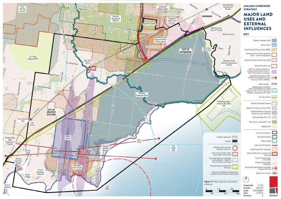
ACS - Figure 17 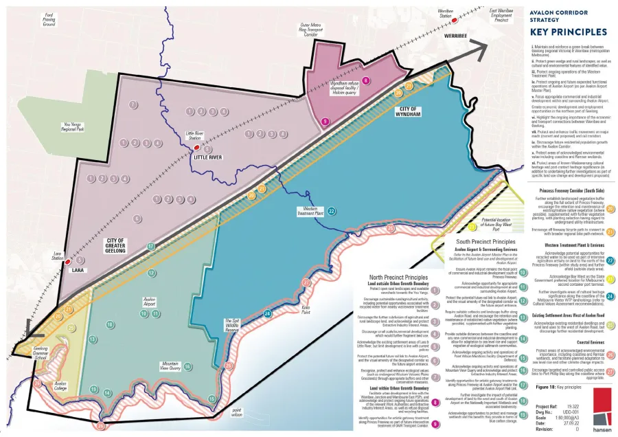
ACS - Figure 18
Click on an image to view details and enlarge
Page last updated: